Alerts and trail status
We recommend checking this page regularly before and during your journey as the route may have changed since planning your journey.
These alerts are set out in order from north to south
Details
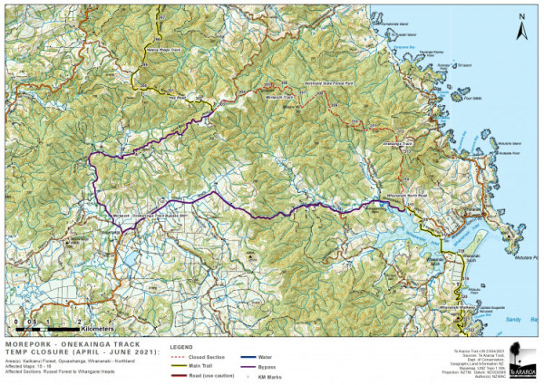
The route using Morepork and Onekainga tracks is no longer available for Te Araroa. These tracks previously connected Kaiikanui road and Whananaki North Road, but a section of the connecting route using private land has been closed to walkers.
Alternative
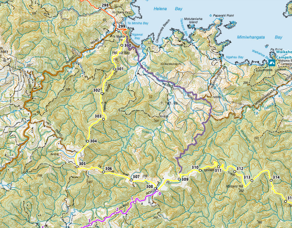
Bypass directions: At the South End of Helena Ridge track at km 308, turn right into Kaiikanui Road, and travel South 9 km to the junction with Pigs Head Road, turn left 0.5 km to Whananaki North Road. Turn left again and proceed 10.5 km along Whananaki North Rd until you meet the trail at km 320.2.
The closure dates on the 2021 map below were optimistic. The Morepork Track has now been re-opened for walkers making day trips into the forest and back, but there is no track connection through to Whananaki for Te Araroa. The road bypass shaded purple below is the only permissible route
Applicable:2021-04-21
ALERT: The entire 5km section of TA trail between the Ngunguru River (km 348.5) and Horohora River (km 354.7) is NOW CLOSED to ALL Te Araroa walkers until September 2024.
Your ONLY option is to take the official TA road detour around both rivers as described on the TA website.
This closure happens every year after the main body of southbound hikers have passed through. The Nikau Bay campsite is used for family camping and cannot provide service for Te Araroa hikers
Directions for Te Araroa road detour around Ngunguru and Horahora Rivers if you are southbound:
From the corner of Ngunguru Road and Pāpaka Road, walk west out of the village and continue on the road margin until you reach a junction with Ngunguru Ford Road (10.5km). Ngunguru Road is a very busy road linking Ngunguru to Whāngārei — take a lot of care walking and stay as far off the edge as you can. Wear a hi-viz vest and do not use headphones. Follow Ngunguru Ford Road southeast for 3km to the start of Mackerel Forest Track. This forest track then travels 4.2km south to the junction of Pataua North Rd. Turn left and walk a further 7.7km to join the trail again on the south side of the Horahora Rivera km 354.7
Applicable:2024-01-03
Northland Regional Council will be completing track upgrades on Helena Ridge Track this autumn for the protection of Kauri and general track improvements. For biosecurity reasons, the track will remain closed while the work is completed. To bypass, Southbound walkers should continue on 4.6km on Webb Rd at km 299.5, then take the right fork (south) to follow on Kaiikanui Rd for 2.9km, where you will rejoin the existing bypass at km 308 described in the Alerts/Trail Notes.
For Northbound walkers heading Northeast on Kaiikanui Rd, continue past the turn to Hay Rd at km 307 and walk 2.9km to the junction with Webb Rd, where you will veer left (west) onto Webb Rd and walk 4.6km join back with Te Araroa at km 299.5.
Applicable:2024-03-26
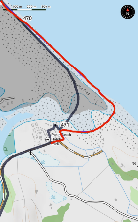
At the southern end of Pakiri Beach immediately before Pakiri River Te Araroa 2023-24 Map 26 published in August showed a line crossing a corner of private land. With shifting sandbanks and changing land ownership this is no longer correct. The website maps were updated 22nd November and now show the correct route. The Trail App on iPhone and Android shows the amended route as below. The updated maps are used in the Te Araroa Notes and Maps app.
It is necessary to continue past the river mouth (southbound) before turning inland along the riverbank for 400 metres. After crossing a the small tidal steam follow the short track away from the river and walk beside the holiday park boundary fence for 100 metres to the signpost. Cross the fence into the picnic area on the corner of Pakiri River Road
On Pakiri Beach the boundary between private land and public access is the MHWM (mean high water mark) line, determined and fixed by survey. Put simply, you can walk anywhere below the high tide line. This is easier to do at lower tide levels.
The correct path is shown in red. Do not cross the grey shaded area. This is private land and is particularly reserved as a nest site for tara iti, an endangered bird species that nests on the sand.
Applicable:2023-10-27
The free campsite at Dome Café has now closed. The previous free campsite is now blocked off and demolition work has begun.
Applicable:2024-02-20
DoC have cut basic steps around the fallen tree that previously blocked the Te Araroa route through Dome Forest at km 488.6
The bypass route marked on Te Araroa map 27, from km 487 to km 490.7, offers an alternative, but is no longer necessary until forestry work re-commences. This is currently expect to happen in May - June 2024
The swingbridge opposite the end of Remiger Road, km 519.7, was been severely damaged by floods in early 2023 and has now been removed. Detour via Puhoi Road (3.6km)between Remiger Road and Puhoi Village. This alert applies until further notice. The end date is unknown at this stage
Please do not attempt to walk this track by fording the river. Loggers are working with heavy machinery on a section of forest very near to the closed track. They have limited visibility and the risk of injury or death for anyone attempting to get past is very real. They report walkers and runners are putting their lives at risk, despite clear signage
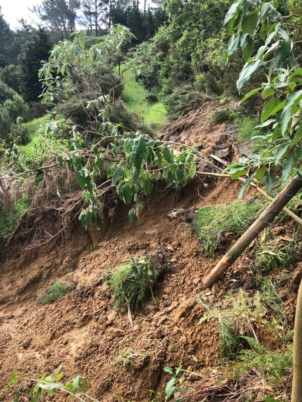
Update 2nd February: Track inspection has found that the Puhoi track is also blocked by a big slip across the track at 1.7 km east of the swing bridge (km 521)
An alternative crossing point (ford) above the bridge site may be developed when logging work has finished and the slip is cleared
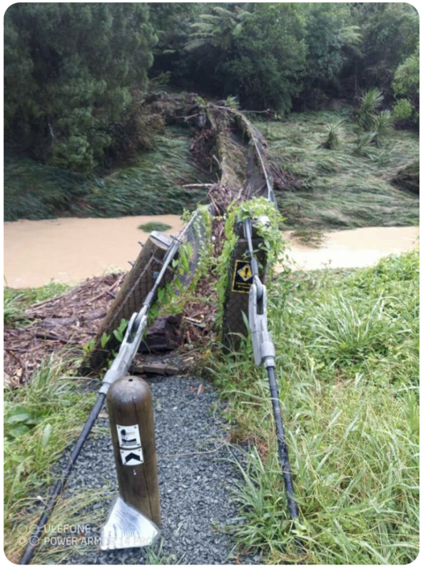

Images may not be visible in some apps
Applicable:2023-01-28
Stillwater Motor Camp has closed. There is no longer a campsite in Stillwater. The next public campsite northbound is at Orewa. It is possible to camp at Dacre Cottage km 560.2. This site is close to the Okura crossing of the Weiti River.
It is a historic site maintained by volunteers. The limited bunk room accommodation is occasionally booked by school groups but is not otherwise available. Camping is free for walkers, with water and toilet. Please respect their generosity in allowing Te Araroa Walkers to use this convenient location
Applicable:2024-04-22
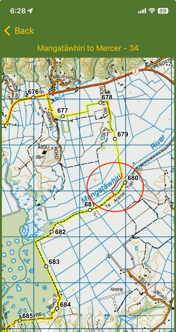
Te Araroa Map 34, from the 2023-24 v42 series, shows an incorrect crossing point. Previous Trail Notes are also incorrect. The correct crossing point for southbound walkers is 330 metres further downstream, as highlighted below. Apps that have not been updated may continue to show the incorrect crossing point as they rely on previous gps data.
- SOBO: turn right from State Highway 2 onto Serpel Road, and in 350 m enter through a farm gate on the left and follow the line of trees to the farm track. Walk along the farm track and in 620 m turn left at the track junction, then right in 140 m and follow the track for another 450 m to its junction with Dobson Road. Turn right onto Dobson Road and follow the orange TA markers 1.8 km to the Mangatawhiri River stopbank. Turn right and follow the stopbank 330 metres downstream to the crossing point, a concrete power pole across the riverbed. It’s marked on both ends by a steel post carrying a large orange track marker, and at this point the river has a gravel bed. If you’re unable to cross the river due to high water levels, follow the stopbank 2.8 km upstream to State Highway 2. Carefully cross then walk under the road bridge to join the other stopbank, and follow that back downstream to the crossing point.
Applicable:2023-10-09
Tongariro Alpine Crossing Red Crater forecast for today.
Link for web browsers and iOS Notes and Maps app only.
Internet connection required
Applicable:2022-11-21
A free booking system will start 2 October 2023 for bookings 14 October onwards. Visitors using any part of the Tongariro Alpine Crossing track should book in advance. As explained by DOC's message below, this should not be a problem for Te Araroa walkers this year.
-
Visitors who turn up to the Tongariro Alpine Crossing without a booking will not be penalised and DOC will not be implementing a cap in 2023/2024. They intend to have the new Manaaki Rangers onsite by 1st November and they will be able to help visitors complete a booking via their phone if they have not already done so – year 1 is about education and behaviour change!
-
Visitors who have a Tongariro Northern Circuit hut or campsite booking are exempt from a booking through the new system.
It is now official policy that the shuttle companies (concessionaires) should only support walkers starting from Mangatepopo and walking northbound. This is not compulsory for individuals, but if you are following Te Araroa southbound you may meet people, including rangers, who tell you that you are going the wrong way. Please explain that this is allowed, although not widely advertised.
Applicable:2023-10-02
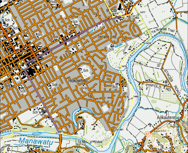
The shared path along the edge of Gasworks Drain will be closed to all pedestrian and cycle access for the duration of the stormwater upgrade work along Gasworks Drain. This closure only affects the trail between 1476km-1478km, but the following bypass (shown in purple) is recommended:
- After leaving cemetery at 1476km, head west (turn right) and follow Napier Rd / Main St for 3km into Te Marae o Hine/The Square in the city centre.
- From the south side of Te Marae o Hine/The Square, head South on Fitzherbert Avenue for 2.1km to rejoin the trail beside the Manawatū River at 1483km.
Applicable:2024-01-09
Details
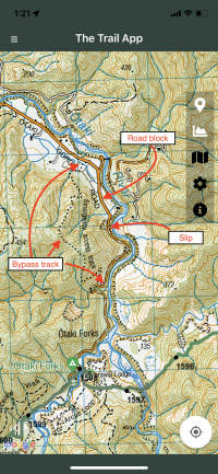
Walkers are advised that if planning to resupply in Otaki the road out to resupply from Otaki Forks (near Parawai Lodge/Hut and km marker 1597) to Shields Flat is closed to vehicles. This is due to slip damage.
If you wish to walk out to resupply in Otaki there is a DOC emergency access track through the forest to the west of Otaki Gorge Road. The track starts along the road north of Otaki Forks and comes out at Shields Flat carpark. This track is marked on the topomap and from Otaki Forks to Shields Flat is approx. 5km one way, expected to take 2-3 hours. Please note this is a challenging walk. More information available on DOC website here - the bypass track is marked on below map.
From Shields Flat it is 11km to SH1 and a further 2km to Otaki township.
Please note that the previous alternative option with a walkway over the slip on Otaki Gorge Road is closed due to further slip movement. Please refer to the Kapiti Coast District Council website for the latest information on access via Otaki Gorge Road
Alternative
Remain on the trail and be prepared to carry enough supplies and food for the walk between Levin to Waikanae - or vice versa.
Applicable:2021-10-20
Details
Walkers are advised that if planning to resupply in Otaki the road out to resupply from Otaki Forks (near Parawai Lodge/Hut and km marker 1597) to Shields Flat is closed to vehicles. This is due to slip damage.
If you wish to walk out to resupply in Otaki there is a DOC emergency access track through the forest to the west of Otaki Gorge Road. The track starts along the road north of Otaki Forks and comes out at Shields Flat carpark. This track is marked on the topomap and from Otaki Forks to Shields Flat is approx. 5km one way, expected to take 2-3 hours. Please note this is a challenging walk. More information available on DOC website here - the bypass track is marked on below map.
From Shields Flat it is 11km to SH1 and a further 2km to Otaki township.
Please note that the previous alternative option with a walkway over the slip on Otaki Gorge Road is closed due to further slip movement. Please refer to the Kapiti Coast District Council website for the latest information on access via Otaki Gorge Road
Alternative
Remain on the trail and be prepared to carry enough supplies and food for the walk between Levin to Waikanae - or vice versa.
Applicable:2021-10-20
The northern section of the Coastal Track in Queen Elizabeth Park is closed due to coastal erosion between Raumati South and just before Whareroa Stream.
Please continue to walk along the beach or use Te Ara o Whareroa, further inland.
A shared path is being installed along Papakowhai Road in Porirua, with construction starting at the end of November 2023 and due to finish by June 2024. Pedestrian access will be maintained during construction as much as possible, however please be prepared to follow workers instructions if a delay or detour is required.
Applicable:2023-12-30
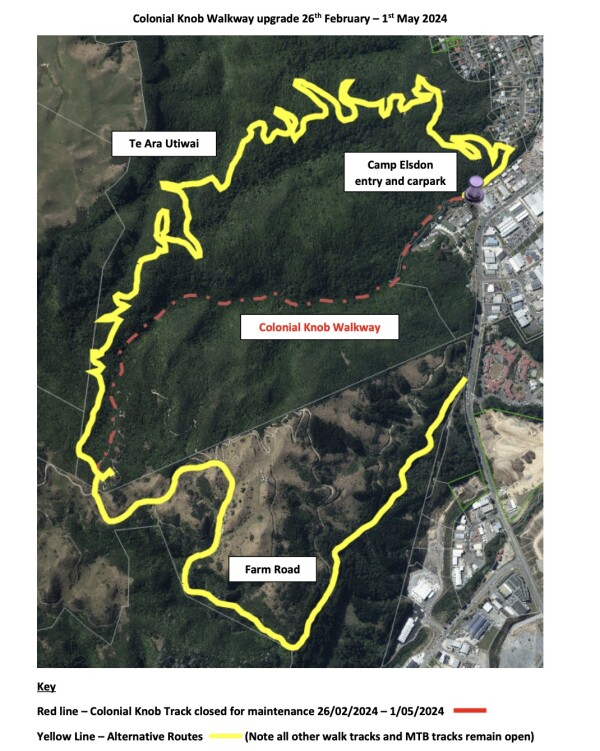
Colonial Knob Walkway is temporarily closed for maintenance works 26 Feb 2024 to 1 May 2024.
Heading SOBO from Camp Elsdon there are two alternatives:
- From Camp Elsdon turn right and follow Te Ara Utiwai track (please note this is a shared uphill mountain biking track) instead of the Colonial Knob Walkway to the lookout.
- Continue a further 500m along Raihia Street from Camp Elsdon and follow the Farm Road track to the lookout.
The creek supplying Camp Bay campsite is very low. Campers must minimise their water usage. Only use water for essential services such as toilet flushing, hand, teeth and dishwashing and drinking (after boiling). No solar showers and please don't leave taps running.
If you are walking/biking between Camp Bay and Torea Saddle/Portage/Cowshed Bay, you must carry all the water you need. There are no side creeks to fill water bottles on the way. The rainwater tanks at Bay of Many Coves and Black Rock campsites are very low. Please leave this water for overnight campers who must only use water carefully for essential services such as hand, teeth and dish washing and drinking (after boiling).
Applicable:2024-03-22
Message from DoC - Mount Richmond Forest Park - Prohibited Fire Season
Due to the recent dry weather and a high risk of fire, a Total Fire Ban is now in place for Mt Richmond Park. All fires are prohibited. This includes cooking and warming fires on the Richmond Range section of Te Araroa trail until further notice.
Update: Clarification from DoC. The Total Fire Ban applies to fires OUTSIDE. In a declared Prohibited Fire Season anything inside a hut or lodge is fine. Outside, the ONLY stoves permitted are “Gas-Operated Appliances” and “Pressurised Liquid Appliances”. No alcohol stoves, twig burners or anything without a shut-off valve.
Applicable:2024-02-15
Help stop the spread of lindavia (lake snow)
Do not swim, wash, take water or put any equipment into these lakes. These lakes hold high cultural significance to Māori, particularly local iwi Ngāti Apa ki te Rā Tō. They are tapu (sacred) and the restrictions have been placed to uphold their mauri (life force) and purity.
The invasive alga lindavia is present in Lakes Rotoiti and Rotoroa. It causes lake snow – a sticky mucus that hangs below the surface of the water. Not touching the water in these lakes will also prevent the spread of lindavia.
Applicable:2022-12-01
Message from DoC - Nelson Lakes National Park and surrounding Public Conservation Land - Prohibited Fire Season
Due to the recent dry weather and a high risk of fire, a Total Fire Ban is now in place for Mt Richmond Park. All fires are prohibited. This includes cooking and warming fires on the Richmond Range section of Te Araroa trail until further notice.
Update: Clarification from DoC. The Total Fire Ban applies to fires OUTSIDE. In the state of Prohibited Fire Season then, anything inside a hut or lodge is fine. Outside, the ONLY stoves permitted are “Gas-Operated Appliances” and “Pressurised Liquid Appliances”. No alcohol stoves, twig burners or anything without a shut-0ff valve.
Applicable:2024-02-15
There has been a track washout on the Harper Pass Route, west of the pass near the old slip site by the Taramakau swingbridge. Expect additional river crossings in this area.
This is about two hours before Locke Stream Hut southbound.
Applicable:2023-09-29
The Sanctuary at Arthur's Pass has closed.
Bill has retired due to old age and has closed The Sanctuary.
Bounce boxes held or already in transit can still be collected as expected.
Text 0274 662 755 on arrival.
No more boxes please.
The community of Te Araroa walkers will always be remembered. Thank you all.
Enjoy your adventure.
Bill Trolove
The Sanctuary
Applicable:2023-12-06