Marlborough trail notes
Section
Intro
Te Araroa's start point in the South Island is Ship Cove at the Queen Charlotte Track's northern terminus. Te Araroa follows this track for 3-5 days (72km) and ends near the Outward Bound School at Anakiwa.
Most people get to Ship Cove by boat. Several companies operate regular shuttle runs between Picton and various points along the track, including both trailheads. Some operators will transport packs forward each morning to the days-end destination so trampers can walk unencumbered.
It is possible to fly from Wellington to Picton or Port Gore, with a shuttle from Port Gore over the hill to Ship Cove. See 'Getting there' for details.
Description
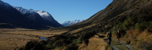
The entire track is a medium tramping standard. It contains long forested sections with a mix of coastal and ridgeline walking and affords gorgeous views of both Queen Charlotte and Kenepuru Sounds.
There has been a lot of tourism-oriented development along the Queen Charlotte Track and trampers can tailor their tramping to suit. The accommodation available ranges from up-market lodges to campsites, six of these managed by DOC and one, at Mistletoe Bay, by a private trust. If you want to spend the money, there's restaurant food available en route.
The Department of Conservation brochure available through the link on this page contains more information about walking the track, including details about transport, food and accommodation options, flora, fauna, and an historical account.
A four day tramp on the Queen Charlotte Track might follow this timetable but there's plenty of scope for variation:
- Ship Cove to the head of Endeavour Inlet - 13km / 5hr
- Head of Endeavour Inlet to Bay of Many Coves Campsite - 19km / 6hr
- Bay of Many Coves Campsite to Torea Saddle - 15km / 6hr
- Torea Saddle to Anakiwa - 20km / 8hr
The walking time estimates are from the Department of Conservation. Some will find them generous but they're consistent throughout the country so if a tramper is able to walk one section in 4/5th of DOC’s walking time estimate, for example, then they're likely to be able to do the same in other sections.
Ship Cove
View the historic site and interpretation panels. The walking begins with a 240m climb to a saddle and lookout before descending to Resolution Bay and Schoolhouse Bay campsite
Resolution Bay
The Resolution Bay Cabins are further along (03 579 9411). The well-graded trail undulates as it leads from Resolution Bay around into Endeavour Inlet passing numerous accommodation businesses along the way.
Beyond the Camp Bay junction the track climbs towards Kenepuru Saddle.
Kenepuru Saddle
The track from the Saddle has some steeper and ridgeline sections. Trampers need their Queen Charlotte Track Land Cooperative (Q.C.T.L.C) pass from here to cross private property track sections.
The Queen Charlotte Track ends here in Anakiwa.
Description
Captain James Cook, the first European to set foot on New Zealand soil, named Queen Charlotte Sound and Ship Cove, where in January 1770, he and his crew on the Endeavour, spent weeks taking on water and provisions. Cook used the cove again on his two subsequent voyages of 1773 and 1777, as captain of the Resolution. This is where he stayed for about 6 months. A memorial to him now stands at the Cove where you can view the historic site and interpretation panels.
Conditions
Queen Charlotte Track Land Cooperative Pass ($30 for 5 days) – Private Land
A Queen Charlotte Track Land Cooperative (QCTLC) Pass is required for all QCTLC Land between Kenepuru Saddle, Torea Saddle, Te Mahia Saddle and Anakiwa, whether walking or biking the Queen Charlotte Track.
The QCTLC Pass fee contributes to the sustainability of the track and assists with maintenance, enhancements and access. Please respect the owners’ property and do not take vehicles, firearms or dogs on the track. The sections of track on these properties only exist through the goodwill and cooperation of the landowners.
Passes can be purchased on the QCTLC website and at the Picton I-Site, Blenheim I-site, Nelson DoC, DoC Wellington and Picton water taxis as well as selected accommodation (Furneaux Lodge, Endeavour Inlet) and various business near the track (Paper Plus, Picton).
Jetties
Many jetties in the Sounds, such as the Outward Bound New Zealand one at Anakiwa, are privately owned. Boat owners can use them for picking up and dropping off passengers and luggage only.
Access
Road or Sea Access Information
Anakiwa, Mistletoe Saddle, Torea Saddle and Kenepuru Saddle are all accessible by road. Anakiwa, Mistletoe Bay, Torea Bay, Camp Bay, Endeavour Inlet, Resolution Bay and Meretoto/Ship Cove can be accessed by sea.
You can walk or ride the track in either direction, but it's best to set from Ship Cove.
If starting from Ship Cove, boat operators are available to carry your pack between accommodation places.
Private transport
Anakiwa, Mistletoe Saddle, Torea Saddle and Kenepuru Saddle are all accessible by road. Anakiwa, Mistletoe Bay, Torea Bay, Camp Bay, Endeavour Inlet, Resolution Bay and Meretoto/Ship Cove can be accessed by sea. Many of the short walks can be enjoyed from these places.
Transport operators
A number of companies offer boat transport to and from points along the track, including Meretoto/Ship Cove. Regular and on-demand bus services link Anakiwa with Picton.
Further information is available from Picton Information Centre, travel companies and accommodation houses.
Transport
Getting there/away - Picton
Te Araroa’s northern terminus in the South Island is at Ship Cove, which is accessible only by boat or by air. Picton is the gateway to Ship Cove and is a full service town with a population of around 3000.
- Ferry to/from Wellington, multiple departures daily, Interislander or Bluebridge
- Pelorus Air (http://www.pelorusair.com) Fly direct from Wellington to Port Gore, landing on a private airstrip over the hill from Ship Cove. A 20min flight with great views along the way. Contact us for more details - info@pelorusair.com Tel: 027 757 7247
- Sounds Air (https://www.soundsair.com) - regular flights between Wellington and Picton (Koromiko airport) with shuttle service to/from Picton. Great scenic flight and only 20 mins! NZ only: 0800 505 005. Tel: +64 (0)3 520 3080. info@soundsair.com
- Air New Zealand
- InterCity - P: 03 365 1113
- Rental Cars - multiple options available
- Private Driver Hire - P: 03 3910500 (Paul) - can transport to/from all locations Picton-Anakiwa-Pelorus Bridge-Nelson-St Arnaud, priced on enquiry.
Ship Cove
- Cougar Line Water Taxis - The Waterfront London Quay and Wellington St, Picton (by the town wharves) - P: 03 573 7925
- Beachcomber Cruises - The Waterfront Cnr London Quay and Wellington St, Picton P: 03 573 6175 or Freephone 0800 62 45 26 - E: office@mailboat.co.nz
Anakiwa
- Cougar Line Water Taxis - The Waterfront London Quay and Wellington St, Picton (by the town wharves) - P: 03 573 7925 - W:
- Beachcomber Cruises - The Waterfront Cnr London Quay and Wellington St, Picton P: 03 573 6175 or Freephone 0800 62 45 26 - E: office@mailboat.co.nz
- Private Driver Hire - P: 03 3910500 (Paul) - can transport to/from all locations Picton-Anakiwa-Pelorus Bridge-Nelson-St Arnaud, priced on enquiry.
Accomodation
Accommodation / Camping
You can choose to walk (or bike) the track independently, carrying all of your own clothing and equipment, or you can simply carry a day pack and have your main gear (less than 15kg) transported by one of the water taxi companies. The campsites at Bay of Many Coves and Black Rock are not at sea level so these are excluded from the water taxi luggage shuttles - you will need to carry everything you need if you choose to stay at these sites.
The six DOC-managed, ‘self-registration’ campsites on the track each have toilets and water supply. Some also have cooking shelters and picnic tables. Remember there are no rubbish facilities. Please take your rubbish with you when you leave.
DoC Camp Site Fees
Update October 2023 DoC have implemented a booking system for the campgrounds, this means you can book and pay online before your trip. Alternatively visit the I-Site in Picton to buy campground tickets.
If you have not booked and paid online you will need to deposit the camp fees ($10 per night, per adult) for the DOC campsites in the self-registration box at each site or prepay at the Picton i-SITE or the DOC Office in Picton. These fees go toward the upkeep of the camp facilities. Note: The Department of Conservation Backcountry Hut Pass ($120 for six months) is not valid at Department of Conservation campsites.
A number of private accommodation providers offer hostel, cabin, motel and hotel lodgings, and tent sites alongside or close to the track. The private tracks that leave the main track to private accommodation are not constructed to the same standard as the Queen Charlotte Track and may be narrow, steep, and slippery when wet. Some private accommodation sites may not be signposted, so make sure you get clear directions when you book.
- Note: No camping is available at Ship Cove.
- DoC Campsite 1. Resolution Bay - Schoolhouse Bay campsite
- The Resolution Bay Cabins ($70 per person, per night for a little Hut, linen included). Tent sites $25 per person. Small shop with espresso and snacks. Kayaks, full kitchen and showers included. Bookings essential - Deborah P: 03 579 9411 E: reso@xtra.co.nz W: Resolutionbay.kiwi
- Furneaux Lodge - Endeavour Inlet, Queen Charlotte Sound - Marlborough Sounds - P: 03 579 8259 - E: info@furneaux.co.nz - This historic lodge has hostel and more exclusive accommodation, a restaurant, bar, and a booking office.
- Top of the Inlet accommodation at the head of Endeavour Inlet (near Miner’s wharf), at the end of the first day's walk on the Queen Charlotte Track. A single tent site or a one-room cabin available. The cabin has a comfortable queen-sized bed ($80 per night for two people inc. cooking facilities and linen). Camping for single tent site $10 per person. Use of cooking facilities, bush shower and composting toilet. Booking essential - Carey P: 027 231 6487 carey.virtue@gmail.com
- Camping available at Top of the Inlet cabins $10 per person per night. Use of cooking facilities, bush shower and composting toilet
- DoC Campsite 2. Camp Bay campsite
- Punga Cove Resort - Endeavour Inlet - P: 03 579 8561 Hostel and more exclusive accommodation options, a restaurant, cafe and bar. E: enquiries@pungacove.co.nz
- DoC Campsite 3. Bay of Many Coves campsite.
- www.ngaherehou.com 1200m off the track, well signposted. Glamping in luxury and comfort. Large yurt (sleeps 4 - $350 per night inc. organic breakfast) or Summerhouse yurt (sleeps 2 - $220 per night inc. organic breakfast) Self-catering, BBQ or our delicious pizzas, wood fired hot tub. 40 acres of private bush reserve with stunning views this is an off-the-grid eco experience to treasure. P: 021 0224 1915
- DoC Campsite 4. DOC’s Black Rock Campsite –
- DoC Campsite 5. DOC’s Cowshed Bay Campsite – (26 Dec to 8 Feb - $15 per night)
- Portage Resort Hotel - 2923 Kenepuru Rd - P: 0800 762 442 or 03 573 4309 - E: reservations@portage.co.nz - Hostel and more exclusive accommodation, restaurant, cafe, and bar.
- Mistletoe Bay Eco Village - Onahau Bay - P: 03 573 4080 or M: 021 131 8283 - E: stay@mistletoebay.co.nz - Camping, hostel, more exclusive accommodation, and a small store.
- DoC Campsite 6. DOC’s Davies Bay Campsite
The Department of Conservation Backcountry Hut Pass is not valid at Department of Conservation campsites. You must pay for camping at the Queen Charlotte Track. Fees are payable to the Queen Charlotte Track Land Cooperative to use track sections that cross private land. A pass lasting up to 4 days costs $30.00. School children are free. Passes are for sale at numerous outlets, including the Picton i-SITE and Furneaux Lodge. This is for access only and does not include camping.
Department of Conservation’s Bay of Many Coves Campsite
The track climbs from this campsite to a high point then undulates gently and stays mainly on the ridge.
Department of Conservation’s Black Rock Campsite
Beyond this campsite the track remains mainly on the ridge before it descends to Torea Saddle
Torea Saddle. Right for 1km down Torea Road to Portage Bay, from here the track climbs away from the saddle. Further on it descends towards Te Mahia Saddle or a side track to Cowshed Bay campsite
Te Mahia Saddle. Left down to Mistletoe Bay Eco Village where there is accommodation, as listed in extra information. The track continues through the junction as sign-posted.
DOC’s Davies Bay Campsite
It is easy walking from the campsite through to the trailhead at Anakiwa.
Picton
Full range of hostel, motel and other accommodation providers including
- YHA Picton - 34 Auckland Street, Picton P: 03 573 6598 E: picton@yha.co.nz
- Gateway Motel Picton - 32 High St, Picton - P: 0800 104 104 or 03 573 6398 - E: info@picton-accommodation.co.nz
- Broadway Motel - 113 High St, Picton - P: 0800 101 919 - E: stay@broadwaymotel.co.nz
- Atlantis Backpackers - 42 London Quay, Picton - P: 03 573 7390 - E: utopia@atlantishostel.co.nz (ask for the Te Araroa discount!)
Anakiwa
- Anakiwa Lodge - 9 Lady Cobham Grove, Anakiwa P: 03 574 2115 E: info@anakiwa.co.nz
- Anakiwa 401 - 401 Anakiwa Rd, Marlborough Sounds - P: 03 574 1388 - E: anakiwa401@gmail.com
- Smiths Farm Holiday Park - 1419 Queen Charlotte Drive, Linkwater - P: 03 5742806 or 0800 727578 - E: cbfaulls@xtra.co.nz (Pickup from Anakiwa available by request)
- "Your Home By The Sea" - Tirimoana Terrace, Anakiwa - P: 03 5742238 - E: yourhomebythesea@gmail.com - Room 1 Queen Bed - Room 2 Double bed bunk (2+1)
- Queen Charlotte Tavern - 1162 Queen Charlotte Drive, Linkwater - Accommodation, WIFI, Shower and a place to do your washing! contact Mary Ann on 027 648 6708 or email on maryannsurridge@icloud.com
Food and Supply
Picton
- Fresh Choice Supermarket - Mariners Mall, 100 High St, Picton - P: 03 573 6463
- Picton 4 Four Square - 49 High St, Picton - P: 03 573 6443
Anakiwa
The Green Caravan Café @ Anakiwa 401 has heat'n'eat meals, snacks, hot & cold drinks and ice-creams.
Intro
Te Araroa trail section: After completing the Queen Charlotte Track, follow the Link Pathway beside tranquil inlets, through forest and farmland, passing through Havelock, the Green Shell Mussel Capital of the World!
Description
This next section of Te Araroa is maintained by a local group whose project, the Link Pathway, is a 42km walking and cycling trail linking Picton to Havelock with a side trail to Anakiwa. Anakiwa is the small village at the southern end of the Queen Charlotte Track. Te Araroa signage will come in due course, but for now, walkers can follow the numerous Link Pathway signs. Take in the impressive views of the Marlborough Sounds and native bush as you follow this community-built path.
The Link Pathway heads out from Anakiwa to the T junction with Queen Charlotte Drive, turn right and continue to Linkwater School some 1.25km distant.
From the school, continue on Queen Charlotte Drive past the Linkwater Service Station. At the end of the Linkwater straight, follow the trail around the Mahakipawa Arm to the next stretch of bush track leading off from the right-hand side of the road. The Link Pathway will take you all the way around the point and into Havelock — a triumph of community vision and energy.
Continue following the Link Pathway crossing the Havelock Causeway Bridge, then a series of beautifully constructed boardwalks will take you across the estuary and up through the historic Havelock Cemetery. Continue on the footpath to SH6, turn right and walk the remaining 100m into Havelock Village.
From the shopping area on Havelock Main Street (SH6), walk west on the footpath and then the road shoulder. 2.5km from the northern edge of Havelock, turn right/west into Te Hoiere Rd. Cross the bridge and continue 1km on Te Hoiere Road, crossing another bridge and reaching Kaiuma Bay Road. Turn left into Kaiuma Bay Road and walk some 9.5km to Daltons Bridge and the start of Daltons Track.
Daltons Track (Special Conditions of Access)
Daltons Track opened in March 2011 following a collaborative process involving the Te Araroa Trust, private landowners, DoC, Marlborough District Council, and Herenga ā Nuku (Outdoor Access Commission).
When you reach Daltons Bridge, the large sign and stile onto Daltons Track will be immediately in front of you at the intersection of Kaiuma Bay Road and Daltons Road laneway - cross the stile, walk over towards the river and follow Daltons Track following the orange triangles.
- This is a working dairy farm. Dairy cows may be present in one or more of the paddocks you walk through and are often curious but never aggressive.
- Note: Under no circumstances should you continue ahead (south) on Daltons Road laneway — this becomes a farm track. It is used extensively by stock and farm vehicles and is not to be entered.
Description
Daltons Track opened in March 2011 following a collaborative process involving the Trust, private landowners, DOC, Marlborough District Council, and Herenga ā Nuku.
Conditions
Te Araroa Trust gratefully acknowledges the generosity of the two landowners allowing us access on to their land. To ensure ongoing goodwill, please respect the following conditions of access:
- Track use is restricted to trampers during daylight hours only
- Stiles are to be used where provided
- Farm operations and stock have the right of way
- No dogs, camping, fires, bikes or firearms.
The track is to tramping track standard. It has a natural grassed surface, stiles over fence lines, and several unbridged creek crossings, which are straightforward in normal flows.
Daltons Track follows the true left bank of the Pelorus River for 6.5km. The route follows the fence line adjacent to (beside) the Pelorus River, and at no time does it follow the farm road / laneway, so, to repeat, please do not use that under any circumstances.
Pelorus
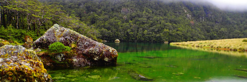
Continue following the orange triangles through the paddocks, the trail then enters the DoC Pelorus Bridge Scenic Reserve. This well marked loop track can be followed in either direction (15mins one way or 20mins the other way) to a swing bridge over the the sparkling Rai River, just before the confluence with the gorgeous Pelorus / Te Hoiere River. It then emerges through the forest at Pelorus Bridge, 100m from the DoC Campground, where there is parking and public toilets.
The stunning green waters of the river pools may tempt you for a dip on a hot day. Otherwise, Maungatapu Road (also known as Mt Richmond Road) lies in front of you, and Te Araroa continues south on that to the Pelorus River track trailhead.
- Note: It is 14km along Maungatapu / Mt Richmond Road to the next trailhead (and 8.5km further to Captain Creek Hut) — there are no budget accommodation options along Maungatapu Road — the Pelorus Bridge Campground should be used.
Access
Northern Start: Northern end of Anakiwa Road, Anakiwa
Southern End: Junction of SH6 and Maungatapu Road, Pelorus Bridge
Transport
Havelock - Getting there/away
- InterCity - P: 03 365 1113 - Daily buses to Blenheim, Picton and Nelson.
- Private Driver Hire - P: 0272 565 643 (Paul) - can transport to/from all locations Picton-Anakiwa-Pelorus Bridge-Nelson-St Arnaud, priced on enquiry. We can take you from Anakiwa to the start of the trail head for the Pelorus track at the end of Maungatapu road, including stopping to re-supply in Havelock en-route. Travel time just under 2 hours including time to re-supply. This saves almost 3 days of road walking.
Pelorus Bridge
- InterCity - P: 03 365 1113 to Blenheim, Picton and Nelson.
- Private Driver Hire - P: 0272 565 643 (Paul) - can transport to/from all locations Picton-Anakiwa-Pelorus Bridge-Nelson-St Arnaud, priced on enquiry.
Accomodation
Anakiwa and Linkwater
- Anakiwa Lodge - 9 Lady Cobham Grove, Anakiwa P: 03 574 2115 E: info@anakiwa.co.nz
- Smiths Farm Holiday Park - 1419 Queen Charlotte Drive, Linkwater - P: 03 5742806 or 0800 727578 - E: cbfaulls@xtra.co.nz (Pickup from Anakiwa available by request)
Havelock
Multiple hostel and motel options in Havelock:
- Rutherford Backpackers - 46 Main Rd - 03 5742104 - E: info@rutherfordbackpackers.com
- Blue Moon Backpackers (BBH) - 48 Main Rd - 03 574 2212 - E: bookings@bluemoonhavelock.co.nz
- Havelock Garden Motel - 71 Main Rd, Havelock - P: 0800 082 222 or 03 574 2387 - E: havelockhideaway@xtra.co.nz
- Havelock Motel - 50 Main Rd, Havelock - P: 0800 111 171? or 03 574 2961 - E: motelbookings@slingshot.co.nz
- Havelock Holiday Park - 24 Inglis St, Havelock - P: 03 574 2339 - E: info@havelockholidaypark.kiwi - Camping, cabins, kitchen, bathroom, laundry - happy to accept bounce boxes though please call ahead to arrange and clearly mark your name and ETA.
Pelorus Bridge
-
DOC Pelorus Bridge Campground - 5949 State Highway 6, Main Rd, RD2 - P: 03 571 6019 - E:sarah.huntley@ngatikuia.iwi.nz - Serviced campground.
-
Campground is open with limited hours as follows - 8:00am-8:30am and 1:30pm-6:00pm during weekdays, and 11:00am - 4:00pm on Saturday and Sunday. You can register for a campsite on the DOC website and a green tag will be waiting for you at the office. Fees: $20-22 per might. The Campground is not covered by the backcountry hut pass, so you must pay on arrival or when you book online. Bounce boxes are welcome for a fee of $10.
- Te Hoiere/Pelorus River runs alongside the campground and is a beautiful spot for a swim. Please do not use any soap/shampoo if bathing in the river (or any rivers along the trail) as this contaminates the water and can harm aquatic life.
- Pelorus Bridge Cafe is currently closed. Re-opening is expected in 2024
-
Nelson
- YHA Nelson - 59 Rutherford Street, Nelson P: 03 545 9988 E: nelson@yha.co.nz
Food and Supply
Havelock
- Four Square Supermarket - 79 State Highway, Havelock - P: 03 574 2166
- Ray’s Place Café – 66 Main Road, Havelock – P: 03 574 1111 – open long hours serving delicious homemade food, seven days a week. Beside the Four Square.
- Slip Inn Café Bar Restaurant – 17 Cook Street, Havelock Port – P: 03 972 0676 – a great place for a meal or drinks overlooking the active port area, beside the Perolus Mail Boat moorings.
- Sneaky Beach Bakery and Café - 65 Main Rd, Havelock - P: 03 574 2860
- Bow to Stern - 75 Main Rd, Havelock - P: 03 5742941 - E: ask@bowtostern.co.nz - full range of goods including footwear, poles, sleeping bags/mats, gas canisters, vinyl/nylon/tent repair kits, rain gear and other incidentals (sunscreen/bug repellent etc). They have an information board displayed - check in for info and/or add any feedback from where you've been.
Intro
Te Araroa trail section: After a long road walk, follow the emerald green waters of the Pelorus River, then head up, along and over the scenic Bryant Range.
Description
From Pelorus Bridge, there is a 14km road walk along Maungatapu Road (also known as Mt Richmond Road) to the Pelorus River Track trailhead. Initially the road is sealed and passes through farm land. Later it is unsealed and has exotic and indigenous forest sections.
Note: There are no budget accommodation options along this road - the Pelorus Bridge campground should be used.
Pelorus River Track
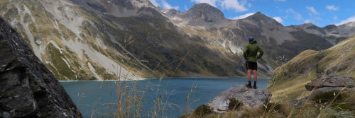
Starting from the end of Maungatapu / Mt Richmond Road, the Pelorus River Track is a long-established DoC tramping track with a good hut system. The track joins directly with Te Araroa’s next section, the Richmond Range Alpine Track, at Hacket Junction. Both these tracks are within the 165,946 hectare Mt Richmond Forest Park and for logistical reasons many trampers will prefer to walk them consecutively as a single 9 (or more) day tramp. This is a major undertaking for which fit trampers should come well prepared. The larger rivers are bridged but the tramp involves many stream crossings that may be impassable after rain. Mt Richmond Forest Park contains a mixed variety of beech and podocarp forest, including the finest rimu along Te Araroa.
Road End to Captain Creek Hut - 8.5km / 4 hour
The track follows the Pelorus River for about a 1 hour to the Emerald Pool picnic area. From here the track climbs upwards. It leaves the river, sidles, and then returns to the river. The 6 bunk Captain Creek Hut is still about 30 minutes further upstream from here.
Captain Creek Hut to Middy Hut - 5km / 2 hour
This undulating section crosses Captain Creek by swing bridge after leaving the hut near its confluence with the Pelorus River. Beyond Captain Creek, swing bridges take trampers across the Pelorus River, and later Fishtail Stream.
Beyond Fishtail Stream the track leaves the Pelorus River then returns to it for the final stretch to Middy Hut (6 bunks).
Middy Hut to Rocks Hut - 5km / 3 hour
From Middy Creek Hut (6 bunks) cross a swing bridge and then climb for 20 minutes to a junction where the Pelorus Track branches to the left. The Rocks Track (to the right) climbs steadily from the junction for about 600m up a broad ridge. It then enters an area with many hummocks and rock outcrops, turning northwards and meeting the Bryant Range near the 16-bunk Rocks Hut.
Note for NZTopo map users. The NZTopo50-BQ26 Nelson map for this region correctly shows Te Araroa leaving the Pelorus Track after Middy Hut and climbing to Rocks Hut. If you are using a phone Topo app or DOC web page to follow Te Araroa and you zoom out far enough the base map will switch to NZTopo250-13 Nelson which incorrectly show the older route, continuing along Pelorus Track via Roebuck Hut to rejoin Te Araroa at Totara Saddle. This route is viable but less frequently used.
Rocks Hut to Browning Hut - 11km / 4½ hour
From Rocks Hut, this track wanders through a landscape of rock outcrop and hillocks. It then climbs over several high points before beginning its descent towards Tōtara Saddle.
The trail emerges onto an open patch of tussock land associated with the mineral belt, an interesting ultramafic rock zone where you notice the vegetation changes drastically, for 15 minutes or so before re-entering the forest and descending - steeply in places - to Tōtara Saddle. From the saddle, the track descends steeply to Browning Hut (8 bunks).
Browning Hut to Hacket Junction - 3.4km / 1 hour
(Plus another 5.7 km or 2 hours out to the Hacket Picnic Area Carpark on Aniseed Valley Road for those finishing this section there).
This is a straightforward section with all intersections well signposted. There is a high/low water track option at one point but this is a bit meaningless as you'll get wet boots in subsequent stream crossings whichever route you take.
Flooding after heavy rain in September 2022 has deposited silt and rubble into the stream, raising the stream bed. This in turn makes the low water track subject to flooding so the high water track is the better option.
At Hacket Junction trampers have the option of continuing on the next Te Araroa section to Hacket Hut, Starveall Hut and beyond or finishing their tramp at the Hacket Picnic Area Carpark. Private transport arrangements are best made in advance if you wish to end your tramp here. Failing which it is a 12km road walk down Aniseed Valley Road to Hope village where a bus can be caught into Nelson.
Conditions
Potential hazards
- Vehicles on road or track on Maungatapu Road
- River crossings - Never cross flooded rivers
Access
Northern Start: Junction of Maungatapu Road and SH6, Pelorus Bridge
Southern End: Hacket Hut Junction
Transport
Pelorus - Getting there/away
- Private Driver Hire - P: 0272 565 643 (Paul) - can transport to/from all locations Picton-Anakiwa-Pelorus Bridge-Nelson-St Arnaud, priced on enquiry. We can take you from Anakiwa to the start of the trail head for the Pelorus track at the end of Maungatapu road, including stopping to re-supply in Havelock en-route. Travel time just under 2 hours including time to re-supply. This saves almost 3 days of road walking
Hope to Nelson - Getting there/away
- InterCity - P: 03 365 1113
- Private Driver Hire - P: 0272 565 643 (Paul) - can transport to/from all locations Picton-Anakiwa-Pelorus Bridge-Nelson-St Arnaud, priced on enquiry.
Accomodation
Pelorus
-
DOC Pelorus Bridge Campground - 5949 State Highway 6, Main Rd, RD2 - P: 03 571 6019 - E:sarah.huntley@ngatikuia.iwi.nz - Serviced campground.
-
Campground office is open with limited hours as follows - 8:00am-8:30am and 1:30pm-6:00pm during weekdays, and 11:00am - 4:00pm on Saturday and Sunday. You can register for a campsite on the DOC website and a green tag will be waiting for you at the office. Fees: $20-22 per might. The Campground is not covered by the backcountry hut pass, so you must pay on arrival or when you book online. Bounce boxes are welcome for a fee of $10.
- Te Hoiere/Pelorus River runs alongside the campground and is a beautiful spot for a swim. Please do not use any soap/shampoo if bathing in the river (or any rivers along the trail) as this contaminates the water and can harm aquatic life.
- Pelorus Bridge Cafe is currently closed. Re-opening is expected in 2024
-
Hope
From Hope it is 29km to Nelson via Richmond. Nelson and Richmond are full-service towns.
- The Pear Orchard Lodge - (BBH) self-catering lodge - max. 20 people - 569 Hill Street South, Hope - P: 03 544 5361 - E: stay@thepearorchard.co.nz - Rooms range from dorm to private rooms with ensuite - pickups from Hacket picnic area with prior arrangement
- Aniseed Valley Cottages - Aniseed Valley Rd (near Hacket picnic area) - P: 03 544 3144 - pickup available from Hacket Picnic Area and (for a fee) guests can be transported to Richmond/Nelson for resupply
Food and Supply
Nelson
- MD Outdoors - Wakatu Carpark, Unit 4/126 Trafalgar Street, Nelson 7010- P: Emily Russell +64 27 606 7977 - Camping, tramping, climbing, trail running, packs, sleeping bags, tents, shoes, socks (including injinji), poles, cooking... all the gear
Hope
- Hope Store and Takeaways - 205 Main Rd, Hope - P: 03 544 9803 - Takeaway meals and light resupply available.