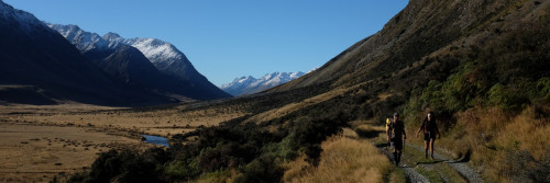
Short Walks

Russell Forest to Whāngārei Heads
Northland, 6 days
This beautiful part of Northland is full of lush native forest and white-sand beaches. This route weaves you in and out of small settlements and forests. It finishes by the steep slopes of Whāngārei Heads. You’ll see kauri trees, marae, holiday camps, and rocky bays.
Russell Forest to Whāngārei Heads on Plan My Walk

Bream Tail to Mangawhai Cliffs Walkway
Northland, 1 day
This stunning beach and cliff-top walkway crosses farmland and bush areas. The high-quality track makes it one of the top attractions in Whangarei. You will enjoy outstanding views of Bream Head, the Hen and Chicken Islands, and the Hauraki Gulf, including the Mokohinau Islands and Great Barrier Island.
Bream Tail to Mangawhai Cliffs Walkway on Plan My Walk

Pūhoi Track
Auckland, 1 day
This was the first Te Araroa track purpose-built for day walkers. Up the Pūhoi Valley, a kilometre past the famous Pūhoi Cheese Factory. To enter the track, you’ll cross a swing bridge over the Pūhoi River. You’ll also see a handful of young kauri trees standing sentry. Untouched mature native trees give you a glimpse of what the New Zealand landscape once was. The track finishes opposite the historic Pūhoi Pub, where locals welcome deserving walkers.

Pirongia Traverse
Waikato and King Country, 2 days
Pirongia Mountain is a distinctive landmark 25km southwest of Hamilton. Pirongia is an ancient volcano. Its dramatic skyline and dark green forests contrast with the surrounding farmland. It offers extensive views of the Waikato Basin across the Kaimai Ranges.
Pirongia Traverse on Plan My Walk
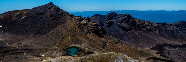
Tongariro Alpine Crossing
Whanganui, 1 day
The Tongariro Alpine Crossing is one of New Zealand’s most spectacular tramping tracks. And it’s the most popular one-day tramp in New Zealand. The Tongariro National Park is a World Heritage site for its natural and cultural significance. The crossing passes over the volcanic craters of the active volcano Mt Tongariro and the base of Mt Ngauruhoe. The walk is famous for its barren yet beautiful “moon-like” volcanic landscape and volcanic activity.
Tongariro Alpine Crossing on Find My Adventure
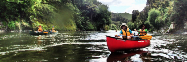
Canoe or kayak the Whanganui River
Whanganui, 4 to 6 days
OK, so strictly speaking, you’re not walking, but you won’t want to miss this wonderful experience. You can enter the river at Taumarunui, Whakahoro or Mangapurua Landing.
At the other end, you can disembark at Pipiriki or continue to Whanganui. Plants and animals abound. If you time it right, you can attend a traditional powhiri at Tieke Kainga.
Whanganui River on Plan My Walk

Palmerston North to Poads Road
Manawatu, 2 to 3 days
This route starts with urban walking Along the Fitzherbert Ave Bridge and cross the Manawatū River. Once you pass Massey University behind, you rise through rural and forestry land. The trail enters the native forest on Burtons Track, which is full of fascinating, pioneering history.
Then the Mangahao-Makahika track continues towards Poads Road. Occasional lookout points give spectacular vistas of the coast.
Once at the end, hardy souls will continue into the Tararua Ranges towards Wellington. But, if that’s not for you, arrange a pickup from Levin, which is close by.
Palmerston North to Poads Road on Plan My Walk

Wellington City
Wellington, 1 day
Starting at the top of Wellington’s famous Cable Car, this route takes in inner-city Wellington’s greatest hits: the Botanic Gardens, historic Bolton St Cemetery, Parliament and New Zealand’s Supreme Court, the ‘golden mile’ of Lambton Quay and Willis St, through Civic Square, and to the splendid Wellington waterfront.
There are plenty of spots along the way to test Wellington’s reputation as the ‘coffee capital’.
Continue past Te Papa, the National Museum, and around Oriental Bay to where this route ends.
Wellington City on Plan My Walk

Pelorus Track
Nelson and Marlborough, 3 to 4 days
The Pelorus River Track is a long-established Department of Conservation tramping track with a good hut system. There are bridges on the larger rivers, but the tramp also involves many stream crossings, which may be impassable after rain.
Mt Richmond Forest Park contains a mixture of beech and podocarp forest, including the finest rimu along Te Araroa.
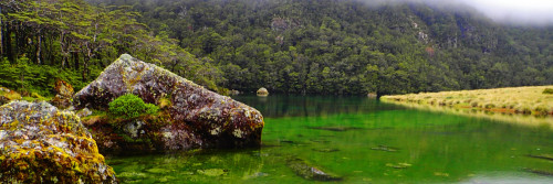
The green pools of the Pelorus River always beckon on a hot day.

East Ahuriri Track
Canterbury, 1 to 2 days
This route is one of Te Araroa’s hidden gems. From Lake Ohau, there is an initial steep climb up Freehold Creek. Once at the top, you get striking views across Lake Ohau and the Mackenzie Basin.
Heading over into the East Ahuriri Valley, you’ll sidle scree slopes and dodge speargrass as you descend to the Ahuriri River. This is the largest unbridged river on Te Araroa.
This track ends at Birchwood Rd, but walkers can continue on the Breast Hill Track to Lakes Hawea and Wanaka.
East Ahuriri Track on Plan My Walk

Gladstone to Wānaka
Otago, 1 day
This breathtaking long, flat walk along lakes and rivers takes in Central Otago’s Māori and early gold mining history. From Lake Hawea, the Hawea River Track follows the river to Albert Town.
The Outlet Track then follows the Clutha to its origin at the Lake Wānaka outlet. Here, you’ll enjoy wonderful views across the lake to the Southern Alps.
Then it’s onto the Wanaka lakefront, where cafes, bars and restaurants lie in wait as a reward for a long walk.
Gladstone to Wānaka on Plan My Walk

Long Hilly Track and Tihaka Beach Track
Southland, 1 day
These two tracks capture some of Southland’s early history and rugged beauty.
The Long Hilly Track is a popular day walk. It takes in many historic mine workings from what was once the largest Chinese mining settlement in New Zealand.
To the south, the beautiful coastline awaits the Tihaka Beach Track. This guides walkers around the rocky shoreline from Colac Bay to Mores Reserve in Riverton. Surfers should keep their eyes peeled for a wonderful example of a left-hand point break curling around the coast.