Auckland trail notes
Sections
Intro
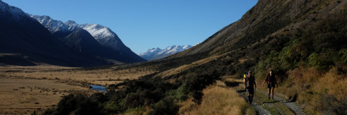
Te Araroa section: Te Araroa's Auckland region begins at Mangawhai Heads, a popular holiday and surf destination accessible by road. From there, it is a long, scenic, beach walk to another holiday settlement of Pākiri
Description
From Mangawhai Heads carpark, follow the road to the walkway by 44 Wintle Street, which leads down to the estuary. Follow the estuary past a camping ground, a boat ramp and holiday baches until wooden steps lead up to the Findlay Street walkway. From Findlay Street, head left into Molesworth Drive. Immediately after crossing the estuary, the trail leaves Molesworth Drive to follow the Back Bay Boardwalk for 1km, bypassing a busy road to enjoy the coastal wetlands on a path built by local volunteers. [Update July 2023: The boardwalk was severely damaged by flooding in early 2023. It may be closed]. The route returns to Molesworth Drive to continue until reaching Mangawhai Village. Then a right into Moir Street, left into Insley Street and across the estuary, then left into Black Swamp Road. Follow this road until reaching Pacific Road, which leads you through a forestry block to the beach and the next stage of Te Araroa.
Once on the beach, just 1km south a stream cuts across the beach and it can go over thigh height, as can other water crossings on this track. Follow the coast southwards for another 2km, then take the track over Te Ārai Point. Track markings near Te Arai Point may be difficult to follow. Take extra care.
Once back on the beach, continue south for 12km (fording Poutawa Stream on the way). As you walk this beach, south of Poutawa Stream it is essential to stay below the mean high tide line to respect private property rights in this area which extend to the mean high-water mark. As you approach the Pākiri River, continue down the ocean side of the beach and cross the river at its mouth. This should be done within 90 minutes either side of low tide to ensure it's safe and possible. Check the tide chart here. NOTE: Do not turn inland before crossing the river. The spit is fenced off for the protection of Tara-iti nesting sites. After crossing, turn inland and loop back toward the holiday park. Cross the small tidal steam and follow the short track along the holiday park fence line that will lead you up to Pākiri River Road.
Environment
This section of coastline is home to two of only four nesting side for Tara-iti (NZ Fairy Tern). With just 40 adults in the wild and 9 breeding pairs, they are likely New Zealand's most endangered indigenous breeding bird. Nesting in a small scrape in the sand, these delicate sea birds are very vulnerable. Nest sites are roped off and signs erected to alert people to the area. If you see these sites, please keep clear and give them space.
Department of Conservation staff and volunteers are on site during the breeding season raising awareness with people who use the beach.
To learn more about the efforts of DOC and their partners to protect Tara-iti, check out the links below:
The NZ Fairy Tern Charitable Trust
Conditions
No dogs allowed
Lower tide best: check best times for walking on Mangawhai Spit
Warning; when heavy rain & high tide coincide these rivers can be deep - never cross flooded rivers.
*Please take care all the way down the beach and avoid entering taped/marked nesting sites of tara-iti, particularly if needing to venture upstream to cross. Where possible, avoid the sand-dune area completely.
Access
Transport
Unfortunately, long haul bus services pass by 19kms away at Kaiwaka so getting to Mangawhai would necessitate a pre-arranged pick up by a willing accommodation provider - see local transport below.
Local transport
Leabourn Shuttles P: 09 423 7416 - E: info@leabourn.co.nz
Accomodation
Mangawhai Heads
- Mangawhai Heads Motel or Camping Ground - 2 Mangawhai Heads Rd, Mangawhai Heads - P: 09 431 4675
- Fairways B&B - 240 Molesworth Drive, Mangawhai Heads - P: 09-431 4042 or 021 619 311 - E: cleaver@fairways.co.nz
- Mangawhai Lodge - 4 Heather St, Mangawhai Heads - P: 09 431 5311 - info@seaviewlodge.co.nz
Mangawhai Village
- Tudor Oaks Motel - 47 Moir St, Mangawhai - P: 09 431 5393 or 027 493 1901 - E: dianne@tudoroaks.co.nz
- Riverside Holiday Park - 41 Black Swamp Rd - P: 09 431 4825 - E: office.riverside@xtra.co.nz - tent sites, caravans, units, kitchen, laundry, wifi and TV/games room.
- Mangawhai Camping - We have a basic cottage and tenting with water, electricity and toilet in our small orchard at the Mangawhai village close to Shops and food. Koha of $10pp appreciated. Call first please on Oh too one, 796 496. Your hosts - Mark and Kerry
- Mangawhai Travellers Rest — 4 Insley St, Mangawhai Village (opp SuperValue) — P: 09 4315389, 021 02377242 (Alan/Lisa) — E: mangawhaitravellersrest@gmail.com — $20 per person inside, $15 per person camping, and a private room for two for $50 — Includes free wifi, recharging, shower and toilet.
Te Arai Point
Car parking, toilets and picnic areas.
No tenting allowed. There is a small SCC campground (up to 10 SCC campervans) for SCC campervans only, pre-booking through the Auckland Council is required.
Pākiri
- Pākiri Beach Holiday Park - 261 Pakiri River Rd, Pākiri P: 09 422 6199 E: info@pakiriholidaypark.co.nz. Reception & Shop hours 9 am – 5:00 pm. Limited numbers of camp sites available for TA walkers at a reduced rate of $20.00 per person per night with a maximum of 6 people. Tents must be within the site markers. Shared cabins subject to availability $30 per night per person. Summer booking are very high, so we highly recommend booking in advance. The Christmas and New Year period is heavily booked and we may not be able to accommodate everyone. We have a communal kitchen with fridges and microwaves, and bathrooms, and laundry facilities available). Showers are 50c for 4 minutes and laundry is $2 per load
- Pākiri Paradise on the Ridge - 505 Rodney Road, Pakiri, phone 021 066 2108, rosiewilk@xtra.co.nz - airbnb - Guest Room. Accepting campers and charging $10.00 pp for site and water. This is south of Pakiri, up the hill near km 476, 200m off trail.
Food and Supply
Mangawhai Heads
- 4 Four Square - 3 Wood Street, Mangawhai Heads - P: 09 431 4656
- Mangawhai Deli - Shop 2, 7 Wood Street, Mangawhai Heads - P: 09 431 5887
Mangawhai Village
- Supervalue - Moir Street, Mangawhai Village - P: 09 431 4585 Hours: Monday to Sunday: 7:00am – 7:00pm
- New World supermarket - 83 Molesworth Drive, Mangawhai. Hours: Monday to Sunday: 7:00am – 9:00pm
Intro
Te Araroa trail section: The trail leaves the northern beaches and coast to head inland to Mt Tamahunga and Matakana.
Description
From the Pākiri Beach access (adjacent to the Camp Ground), follow Pākiri River Road for 3km to the intersection with Pākiri Road. Cross over and continue south on Bathgate Road, past the school and several houses.
Beyond the southern end of Bathgate Road, go down what looks like a driveway to the Te Araroa sign. Follow the orange track markers leading up a ridgeline through steep farm pasture for 2.5km to a farm track near the end of Rodney Road. This climb offers fantastic views up the coast.
At the end of the ridge the track turns right (west) at a junction. The track to the left leads out to meet Rodney Rd. DOC have installed a long drop toilet on the spur track approximately 120m from the Te Araroa trail junction, close to Rodney Road. A little further off trail at 505 Rodney Road there is a campsite charging $10.00 pp for site and water – use the DOC toilet. Total 250m from Te Araroa.
The track turns west through more farmland and across a steep and muddy saddle (do take care when wet) before climbing through pine plantation into DOC native bush. At the summit, there is a helicopter platform which makes a good spot for resting.
Continuing on, this rough and occasionally slippery track soon descends steeply down before climbing again and passing beneath a weather satellite station. There's another rocky and slippery descent before the track levels out through regenerating bush.
A grassy hill affords some views (between the gorse) of the coast before continuing west on a well-formed track. The track leaves the ridge, crosses a stile and descends 200m to another stile before a narrow and slippery track takes walkers down, across a footbridge and to a short boardwalk across a swamp before another narrow, steep and slippery climb to Matakana Valley Road.
There is a possible koha campsite at private house at 777 Matakana Valley Road, just across the road.
Head south on Matakana Valley Road for 450m to the junction with Govan Wilson Road. If in need of re-supply, Matakana is 6km south down Matakana Valley Road.
Conditions
Be considerate of animals and keep to the track; leave gates as you find them; no dogs, horses, guns, bikes or vehicles.
Potential hazards
- Few water sources
- Wasps are common on the section between Rodney Road and Mt Tamahunga
Access
Transport
Matakana
Long-haul bus services to stop 9km away at Warkworth, the nearest town on SH1.
- InterCity - P: 09 583 5780 - E: info@intercity.co.nz
- Northliner Express Coach Service - Paihia - Auckland - Wellington - P: 09 438 3206
- Naked Bus - P: 0900 62533 (calls cost)
Local transport/transport to the trailhead
- Matakabs - P: 09 422 2244 or 0800 522 743 - E: bookings@matakabs.co.nz
- Warkworth taxis - 54 Burtram St, Warkworth - P: 09 425 0000
Accomodation
- Pākiri Paradise on the Ridge - 505 Rodney Road, Pakiri, phone 021 066 2108, rosiewilk@xtra.co.nz - airbnb - Guest Room. Also accepting campers and charging $10.00 pp for site and water. This is south of Pakiri, up the hill near km 476, 200m off trail
- Matakana Village Cottages (SC, B&B) - 202 Matakana Valley Rd - P: 09 422 9337 or 021 189 4242 - E: cottage@xnet.co.nz
- Glamping Opportunity - Great house with an amazing view located at 732 Matakana Valley Rd - so just down from the end of the trail. The owners are happy to offer a 10% discount to those who are doing Te Araroa walk, just mention this when you book.
Food and Supply
- Matakana Four Square - 21 Matakana Valley Road, Matakana - P: 09 422 7213
- Matakana Store and Post Centre - 21 Matakana Valley Rd, Matakana - P: 09 422 7213
Intro
Te Araroa section: Puhoi is situated on the beautiful Puhoi River and is one of New Zealand’s historic villages. It was originally settled in 1863 by immigrants from Bohemia, an area which is now the Czech Republic—situated 40km north of Auckland and the gateway to Matakana Coast and Country.
Description
Govan Wilson to Dome — 15km / 6-7 hours
- Warning: this track crosses private forestry land in the Waiwhiu Valley. Open daylight hours only — no camping, fires, dogs, horses, or vehicles.
Walk 3km to the end of Govan Wilson Road to the marked steps up onto the track.
Once up the steps from Govan Wilson Road, follow the clay four-wheel drive track. It passes a private home, so please keep to the track. Enjoy the views and the rusty old bus while following along the ridge to the junction with Conical Peak Road.
The house owners provide a basic tent site. A compost toilet and some water may be available. The entrance gate is on the right, a little further down to road past the old boat, at km 485.1
Just before reaching Conical Peak take the right fork off the gravel road and continue on this 4WD clay track until reaching a turnoff on the left onto a narrow bush track in DOC’s Tōtara Scenic Reserve.
At km 487 there is a trail junction. The original Te Araroa route branches off to the left. At some point during the 2023-24 season this track will be closed due to forestry work near Waiwhiu Road. An alternative route continuing the 4WD track to the right, labeled Govan Wilson Rd - Dome Track on Map 27 (v42), provides a safe bypass. This bypass is now signposted from km 487 and is recommended, as a large fallen tree on a steep slope is blocking the original route at km 488.6. The bypass descends for 4 km to meet a grassy forestry road. Turn left and walk 0.5 km, passing under a fallen pine tree and over a concrete ford to a forestry road junction. Turn left again and walk another 0.75 km to rejoin Te Araroa at km 490.7. Turn right onto a clay 4WD road (Fisher Road)
This paragraph describes the original route. The directions given do not match the bypass. Follow the marked bush track, which eventually descends steeply down the ridge into the Waiwhiu Valley. At the bottom of the hill, the track turns right across a small creek and follows the true right of the Waiwhiu Stream for approximately 1.3km. At this point, the track crosses the stream (take care not to slip) to enter private forestry land.
DOC has installed a long drop toilet between the Waiwhiu Stream crossing and Waiwhiu Valley Road, km 490.1.
This paragraph describes the original route. The directions given do not match the bypass. The track joins the Waiwhiu Valley Road, a private forestry road. Turn right and follow the road for approx 300m. Turn left onto a clay 4WD road (Fisher Road — however, signage may be removed).
Fisher Road climbs steeply through pines. Just over the hill’s highest point, the track turns off the 4WD road (easy to miss) into the pines for a short climb to the ridgeline and DOC’s Dome Forest.
This narrow bush track now follows along the ridgeline through attractive podocarp and broadleaf forest with glimpses of the surrounding countryside and coast.
The track climbs to the Dome trig. Then there are a few more ups and downs along the ridge, including a steep scramble around large rocks, on the way to the Lookout platform with views across the Mahurangi Peninsula to the Hauraki Gulf. The track then descends 1km on an upgraded walkway and steps to the Dome Cafe carpark and SH1. The Dome Cafe is closed, but the owners have kindly provided a camping space for Te Araroa hikers. Unfortunately the water supply has failed. Water and toilet are no longer available.
Dome to Moirs Hill — 16km / 4-5 hours
- Warning: Forestry and farming operations
- SH1 is a busy road. The crossing has been modified to make it safer but take care as motorists may not be expecting pedestrians crossing
Immediately across SH1 from the Tearooms is Kraack Road. Follow this road up to a forestry gate. Pass the gate and head along a southwest forestry road. Take a left down another track heading southwards, then cross westwards through regenerating native bush. This is thinly marked through to Smyth Road.
Follow Smyth Road south, turn right into Kaipara Flats Road, then left into Streamlands/Swamp Roads.
Turn right (west) into Old Kaipara Road and keep an eye out for the entrance to #121 when the route is marked up the driveway. Follow the markers up the driveway and around the edge of a fence (not up the driveway to the house), then follow the marked fenceline up to and along the ridge to Edgerley Road; please use the stiles. Give stock a wide berth — they are very friendly.
Follow Edgerly Road for 1km before turning right (west) onto Woodcocks Road. A further 500m along, take a left into Matthew Road and follow it for 1 km. Running off the end of Matthew Road is a forestry road to bring you up to the summit of Moirs Hill. As the forestry track runs onto Moirs Hill Road, continue straight ahead past DOC’s Waihunga Track and the radio transmission tower shortly after.
A gate and Private Property sign block vehicle access to the forestry road at the end of Matthew Road. Te Araroa walkers are welcome to squeeze around the gatepost on the left end of the gate and continue up the hill, following the forestry road.
Just east of the transmission tower is a Te Araroa-signed track that heads 1.7km south down to Ahuroa Road. Signage indicates 5 km to Remiger Road and 9.5 km to Puhoi.
Note: stay on the clay/grass track. The gravel track you may see occasionally is a neighbouring forestry road. There are few markers as there is just pine and gorse for much of the way.
Dunns Ridge Track — 2.5km / 1 hour
- Warning: Farming operations and predator control — please do not freedom camp in this area
From the Ahuroa — J Tolhopf Road intersection, head south 1km down J Tolhopf Road until you pass a rural residential subdivision, then reach a widened area of the sealed road with car parking. Enter through the gate just past the carpark, and follow the fenceline up and over the ridge to the bushline.
From this bushline, follow orange markers across and through part of Dunn’s Bush (a Queen Elizabeth II National Trust reserve, with loop tracks back to Ahuroa Road) until you pass the “Sugarloaf” rock formation. A stile is in place if you want to climb up to this very peaceful and picturesque spot with beautiful views across the valley and out to the coast.
Otherwise, keep heading southeast on the ridge and follow markers through the farm paddocks. The route briefly joins a farm track and then leaves it again to follow the fenceline — please stick strictly to the marked route and follow the fenceline, descending steeply to Remiger Road.
On reaching Remiger Road turn right and cross the bridge over a small creek. On the left, the Remiger Road Conservation Area offers free camping with a small shelter, picnic tables, water supply (treatment recommended) and a toilet. Camp on the grass near the shelter, avoiding the young trees and shrubs planted to enhance this DOC site.
Follow Remiger Road 1km to the intersection with Ahuroa Road. Directly opposite there was previously a swing bridge onto the Puhoi Track. The bridge was destroyed in the flooding and storms in January 2023. An alternative crossing point, starting on the other side of the concrete road bridge to your left and forwarding the smaller stream, is being developed. At the time of writing (August 2023) this route is not available as there is further damage along the Puhoi Track. Turn right and follow the road 4 km to Puhoi village. The road is narrow with poor visibility for traffic.
Conditions
Potential hazards
- Vehicles on road or track
- Poisons & traps
- Farming operations
- Forestry operations
- River crossings - Never cross flooded rivers
- Small stream crossings
- Track exposed to sun, wind or cold
- Few water sources between Dome and Puhoi
No dogs allowed
For tramping tracks, it’s recommended you carry appropriate safety gear including a map, compass, whistle, warm clothing, raincoat, basic medical kit, strong footwear, food and water. Cellphones can work on the ridgelines.
Access
Transport
Getting there/away
Long haul bus services stop 9km away at Warkworth, the nearest town on SH1.
- InterCity - P: 09 583 5780 - E: info@intercity.co.nz
- Northliner Express Coach Service - Paihia - Auckland - Wellington - P: 09 438 3206
- Naked Bus - P: 0900 62533 (calls cost)
Local transport/transport to the trailhead
- Warkworth Taxis - 54 Burtram St, Warkworth - P: 09 425 0000
- Matakabs - P: 09 422 2244 or 0800 522 743
Accomodation
Govan Wilson
- Twin Rimus (Matt and Jas) - Cottage for rent at 107 Govan Wilson Rd. Book in advance through airbnb https://abnb.me/EwAdz3J67lb
Dome to Moir Hill
- Roma and Graham at Totara Bend are located on Woodcocks Rd between Edgerley and Mathews Rd directly on the trail at km 507.5. Campsites and shower available please ring or text before to make sure they have room – mobile 021 759 991. They also have a glamping cabin and self-contained unit if you fancy a bit of a treat at reasonable prices. Water available to refill your water bottles.
- 396 Moir Hill Rd - 1 km off trail. Te Araroa thru-hiking alumni Stu has a woolshed with some bunk beds and plenty of camping space to host walkers. Koha for camping and shed, or do some weeding to save some money. Shower for $5 may be available depending on tank water supply. He might be able to give rides to Warkworth for supplies or drop off in Puhoi, but not guaranteed. Check in with Stu - 027 447 7159.
Warkworth
- Walton Park Motor Lodge - 2 Walton Ave, Warkworth - P: 09 425 8149 - E: info@waltonpark.co.nz
- Ribbonwood B&B - 7 Thompson Rd, Warkworth - P: 09 422 2685 - E: berris@ribbonwoodwarkworth.co.nz
- Trail Angel, Warkworth - Carolyn and John Caukwell Phone or WhatsApp 021 274 1724. Share our home/pitch your tent, and recharge. Hot tub, dogs and cat available to walkers. May be able to collect from Dome. Max 4 walkers per night
-
Free accommodation offered on Sandspit Road, near Warkworth. Double tents available, or put up your own. Fresh running creeks deep enough to swim in. 5 min walk to town centreFriendly kiwi family (grandparents, solo dad, 15yr boy) house is away from tent area so privacy guaranteed unless you want to share a drink or two with BBQ.Sight seeing available, P: Bob 021 026 80267
- Todd & Kip. Trail Angels. Plenty of room to pitch tents but anyone is welcome to a spare bed and a hot shower when available. Happy to pick up from the dome. LGBTQ friendly. Txt or call Todd on 021 654 043
Detour option for accommodation - 2 km south
Warkworth Sheepworld Caravan Park - Cabins and camping - SH 1, Dome Valley, Warkworth - P: 09 425 9962
Food and Supply
New World Supermarket - 6 Percy St, Warkworth - P: 09 425 1040
Intro
Te Araroa trail section: Enjoy a mix of forest types with good bird life and views of Puhoi Valley.
Description
UPDATE 4th October 2023
Extreme rainfall in January severely damaged the Puhoi swingbridge at km 519. The bridge has now been removed. There is severe damage further along the Puhoi Track and forestry work is now being carried out while the track is closed.
It is necessary to use Puhoi Road from Remiger Road to Puhoi Village. Northbound walkers should not attempt to walk the track that starts in the Puhoi Domain across the river from the pub as there is danger from forestry work and they will not be able to re-cross the stream at the northern end of the track. Check the Trail Status Alerts for any change to this situation
Conditions
Potential hazards
- Vehicles on road or track
- Poisons and traps
- Forestry operations
- Few water sources
Access
Accomodation
- Puhoi Accommodation - self contained backpacker style accommodation for up to 6, plus caravan and tent space, - 10 minutes walk from the end of the track - P: Pip 09 422 0009 or 021 722 266 - E: pipbeagley@gmail.com
- Puhoi Hotel Pub and Bistro - Corner Saleyards and Puhoi Rd, Puhoi (limited accommodation) - P: 09 422 0812 - E: thepuhoipublimited@gmail.com
- Pear Tree Farm, Homestay accommodation, two double rooms available, bathroom, kitchenette, laundry and other facilities, Wi-Fi, TV etc. Pick up can be arranged from the end of the track. Ph Carrie 0220815793 or E iwalk@xtra.co.nz
There is no official camping in Puhoi, but a polite enquiry at the Puhoi Hotel may prove worthwhile. Puhoi is a Te Araroa friendly town
Food and Supply
- Puhoi Hotel Pub and Bistro - Corner of Saleyards and Puhoi Rd, Puhoi - P: 09 422 0812 - E: thepuhoipublimited@gmail.com
- Puhoi General Store (Coffee, food, supplies and post shop) - 109 Puhoi Rd, Puhoi (open daily 7am to 7pm) - P: 09 422 0818
- Puhoi Cottage and Tea Rooms - 50 Ahuroa Rd, Puhoi (open Friday to Sunday 10am to 4pm) - P: 09 422 0480
Puhoi River Canoes - Puhoi Village (opposite Historic Church) - Open 1st Sept - 30 June - P: 09 422 0891 or 027 284 1672 - E: puhoicanoes@clear.net.nz
Intro
At the present time, the walking route to Wenderholm Regional Park is incomplete so, on an outgoing tide, you can hire a kayak for the downstream journey to Wenderholm.
Conditions
Tide information for Puhoi to Wenderholm by kayak
- Poisons & traps at Wenderholm Regional Park
- Tides, waves & rivers - safer at low tide - better to paddle (SOBO) on outgoing tide, or (NOBO) incoming tide
- Water - wear a lifejacket.
No dogs allowed
Access
Transport
Canoe and Kayak Hire
- Puhoi Kayaks - 84 Puhoi Rd, Puhoi (Opposite the Historic Puhoi Church) - P: 027 484 1672 Puhoi Kayaks (formerly Puhoi River Canoe Hire) are part of the Puhoi to Wenderholm section of The Araroa. Price is $50 per person. Hire includes Kayaks, all safety equipment and transport of your gear to your finish point. Opening times - Daily 1st Sept - 30th June (Closed - Christmas Day)
- Hibiscus Kayak Hire - P: 021 133 6938 - E: info@kayakhire.co.nz - $45 for Puhoi River, $50 for half-day (4hr) or $70 for 1-day hire if you want to go further (pickup/delivery fee may apply depending on final destination). All hire includes kayak, paddle, lifejacket and drybag.
- Auckland Sea Kayaks - P: 0800 999 0899 (Freephone) - Operating throughout the summer months
Note: Exchange the kayak for your pack at the ramp on the Puhoi River side of Wenderholm Regional Park.
Requires an outgoing tide - check tides at Niwa Tide Calculator
Accomodation
There is camping available at the Schischka Campsite, turn left and walk 1km just after the Wenderholm main gates.
Please do not freedom camp anywhere else within Wenderholm Regional Park.
Intro
Should tides not suit, or you don't wish to pay for kayaking from Puhoi to Wenderholm - it can be walked. When walking along SH1, please take caution as this road is very busy, and there are areas where the road shoulder is very narrow. SH1 is particularly busy during weekends (Friday-Sunday), public holidays, and from Christmas through to the and of January. There are also significant roadworks in this area, due to construction of the new motorway. We recommend kayaking as it is much safer and more enjoyable than walking these busy roads.
Description
Please wear a hi-viz vest and/or pack cover if available
The road south from Puhoi passes under and through extensive road construction. The path through this area is subject to change. Watch for local signage and directions
From the Puhoi Domain, turn left/east and walk 1200m to SH1. Pass under the motorway bridge (under construction) and cross SH1 with extreme caution, then turn right/south, walking 2km on the east side of SH1, behind the barrier where possible.
Take the "offramp" towards Wenderholm/Waiwera as signposted on the Twin Coast Discovery Highway, then continue east a further 2.75km to the entry to Wenderholm Regional Park (Schischka Road).
It is 1km down the driveway to the start of the next route.
Conditions
Cross SH1 with extreme caution as cars are travelling at 80-100km/h. Walk as far off the road shoulder as you can, on the far side of the barrier fence where this is possible.
Potential hazards
- Vehicles on road or track. Walk well off the road, over barrier where possible
- Motorway construction and road works. Follow any instructions given by traffic management staff and signage.
- Track exposed to sun, wind or cold
- Few water sources
Access
Northern Start: Puhoi Village
Southern End: Wenderholm Regional Park
Accomodation
Wenderholm Regional Park - Basic camping, duty ranger - Auckland Council - P: 09 366 2000
There is camping available at the Schischka Campsite, turn left and walk 1km just after the Wenderholm main gates.
Please do not freedom camp anywhere else within Wenderholm Regional Park.
Intro
Te Araroa trail section: This section includes a low-tide walk and rock hop, and a fantastic view of the trail down Orewa Beach.
Description
Wenderholm to Orewa Estuary - 11.5km / 3hr
- Low tide route only
Requires an outgoing tide - check tides at Niwa
From the Puhoi River boat ramp at Wenderholm Regional Park, follow the sealed carpark road south-east for 200m to the Park's Information Board. Here, a map of the park is displayed. Walk through the grounds of the historic Couldrey House to join the Perimeter Track (clockwise over the headland is the most picturesque and has great views). Exit the track by the Waiwera Bridge on the Hibiscus Coast Highway. Cross the bridge and head down Waiwera Road to the beach. Time your walk so that you reach here about half an hour before low tide.
At low tide, it is an easy walk and rock hop around rocks to Hatfields Beach. Beware of slippery rocks.
At the southern end of the beach, take the public walkway steps up to Ocean View Road and follow the walkway signs south via footpaths back out to the Hibiscus Coast Highway. Just over the hill to the south is Lookout Point and the most fantastic view down Orewa Beach – a great sight no matter what the weather.
Note: Optionally, you can avoid Lookout Point by walking along the beach and rocks from Hatfields to Orewa at low tide. This option, however, would bypass the elevated coastal views.
Continue down the hill and walk through Arundel Reserve to Orewa Beach. About 1.5km south is the Orewa Beach Shopping Centre. (Orewa Beach is approx 3km long in total).
Orewa Estuary to Stillwater - 13km / 3 hours
From the southern end of Orewa Beach, follow the path to the bridge over the Orewa River.
At the south end of the bridge, take the path next to the bridge and turn west underneath the bridge onto Te Ara Tahuna (The Orewa Estuary Cycleway and Walkway)
Follow Te Ara Tahuna approx. 2.5km to the intersection of Longmore Lane and Millwater Parkway then turn south for 1km.
Turn right/south at the intersection of Millwater Parkway and Silverdale Street. On your left is the Silverdale Centre with a selection of shops, including a supermarket, outdoors shop and pharmacy. To your right are multiple banks (with ATMs), fast food outlets, butcher and greengrocer.
Continue on Silverdale Street to the intersection with Hibiscus Coast Highway where an underpass takes you safely under the road, and onto Tavern Road (past the historic Wade Tavern), up the hill to Forge Road/East Coast Bays Road.
Turn south onto East Coast Bays Road and walk 2km to the intersection with Spur Road. Turn east onto Spur Road and walk 1.4km to where it leads into Duck Creek Road. Continue a further 5km on Duck Creek Road to the Stillwater Boating Club where the next track commences. This road is narrow and winding with poor visibility. Duck Creek Road will be bypassed when the PenLink road bridge is built, but that is a long time away. It is often possible to hitch from the top of Spur Road
Conditions
Potential hazards
- Vehicles on road or track Take extreme care on East Coast, Spur and Duck Creek Roads heading to Stillwater
- Poisons & traps at Wenderholm Regional Park
- Tides, waves & rivers - safer at low tide
No dogs allowed
Access
Accomodation
Waiwera
There is no accommodation in Waiwera - the options you have are Schischka campground in Wenderholm Regional Park (north) or hostel/motel/campground accommodation in Orewa (south).
Orewa
Silverdale
Silverdale Bed and Breakfast - 41 Whangaparaoa Rd, Silverdale (600m off the Te Araroa route) - Apartment - Studio - Caravan - P: 09 4211460 - E: Seaside_BnB@xtra.co.nz
Stillwater
- Kereru Cottage - Stillwater Cres - P: 021 832358 (Lisa)
- Feijoa Cottage - 389 Duck Creek Rd, Stillwater - Contact Jane on 021 037 5338. Set on a rural property in Stillwater, Feijoa Cottage is a fully self-contained home away from home. If you're walking the Te Araroa Trail and want a night of luxury in a comfortable bed, a nice hot shower, to cook up a yummy meal and do your washing - you'll be walking right past their door.
- Stillwater Motor Camp, which may be listed on FarOut, closed April 22nd 2024
Food and Supply
Waiwera minimart - 2 Waiwera Rd. Waiwera - P: 09 426 1470
Silverdale Centre - 61 Silverdale Street, Silverdale - P: 09 426 4716 - Includes Countdown Supermarket, pharmacy, outdoors store (Macpac), food outlets, The Warehouse, barber etc.
Intro
Te Araroa trail section: Follow Okura Bush Walkway around the coast before crossing Okura Estuary. Be careful not to disturb dotterels.
Description
Low tide route
Check with NIWA for times to walk at low tide.
Updated advice for Okura Estuary 14 September 2022: The tide calculator will indicate the water depth at the estuary crossing point above a standard level for Okura, of between 0.30 and 1.10 metres. Adding 0.15 m to this number will give a predicted maximum water depth across the deepest part of the channel at the recommended crossing point, near the south shore. Storm conditions and atmospheric pressure may alter this depth slightly.
From the jetty or ramp near the Stillwater Boating Club (Tel: 09 428 2185), walk to the eastern end of Duck Creek Road and the start of DOC’s Okura Bush Walkway. Follow this track around the coast, initially on grass and then along the beach past the historic Dacre Cottage to Dacre Point. At or near low tide you can walk along the beach and rocks below the cliffs all the way. At higher tide level there is a scenic track over the headland before Dacre Cottage. You can wade across the Okura Estuary at low tide (roughly hip-deep at the fourth steel pole marker in from the river mouth) across to the southwest end of the cliffs opposite. From the tip of the rocky Dacre point, look across to the headland. The cliffs at left drop down to a small bay where Te Araroa resumes. To the left of that bay from your view, where the cliffs are low, you should see a tall narrow steel pole. This is the fourth similar pole counting from left to right. Ignore the smaller wooden or white painted poles. From Dacre Point walk across the mud flats to the fourth pole and then turn right to continue into the bay where the grass comes down to beach level.
Stingrays feed in the shallow water of the estuary. They are not aggressive, but do not like being stepped on. To avoid contact tap the mud ahead with a hiking pole or splash the surface to disturb them
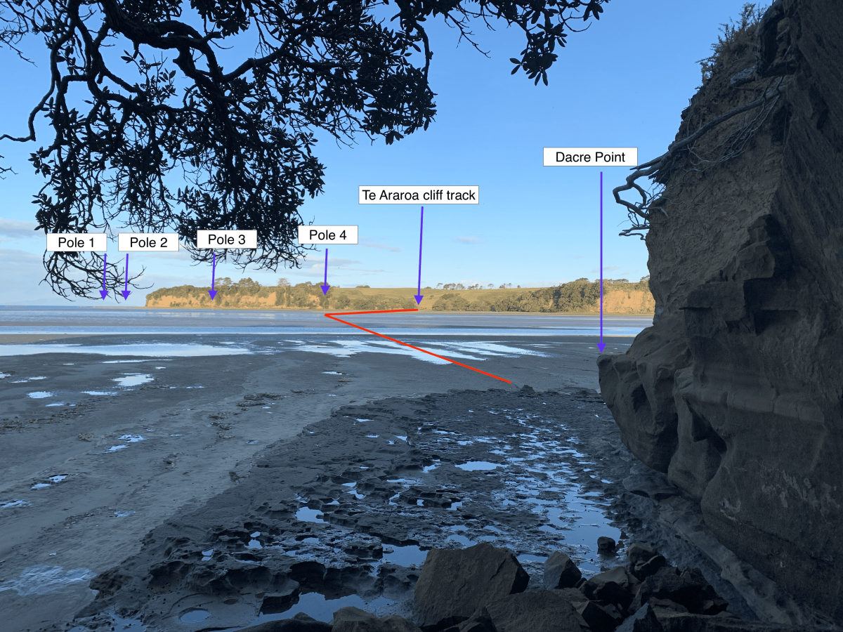
Northbound: Come off the cliff track into the beach. Turn right towards the river mouth 100m, then cross towards the fourth pole from the mouth. You are looking for thin metal posts, not big white ones, which are further upstream. The fourth pole should have an orange marker attached. This has been dislodged after storms on occasion. Once at the fourth pole turn slightly left and head due west to the tip of Dacre point.
Southbound: Walk to the very end of the Dacre Point. You are targeting the small bay at the right end of the cliffs nearest the river mouth. The four narrow metal poles are can be seen from that point although it may be difficult to spot the ones nearest to the river mouth. Cross to the fourth pole from the river mouth. The pole to aim for should have orange triangle markers attached. At low water the base of the fourth pole is usually standing on mud just above the water next to the deeper channel. Low tides are variable so the pole may be standing in water even at the lowest tide on some days.
Once across the estuary channel (southbound), veer to the right around the southwest end of the cliffs and up into the Long Bay Regional Reserve. Pick up the coastal (cliff-top) track that heads southeast to Long Bay. Note: This track passes Pohutukawa Bay, a male nudist beach.
While the tide is low it is possible to walk to Long Bay along the beach and rocks below the cliffs. The rock surfaces are very slippery when wet.
Update April 2023. The cliff-top path is closed between km 563 and km 563.5 due to severe and continuing track subsidence. The closed section may be bypassed by using the coastal track between Pokutukawa Bay (km 563) and Granny's Bay (km 564.2)
Update August 2023. The state of the cliff-top path is unknown. it is possible the the slip has been repaired
Shallower crossing route including 5km road walk
If the tide is not low enough for the normal estuary crossing there is an alternative crossing point at the sandspit, further up the Okura River
The official route, including the main estuary crossing near Dacre Point, is preferred if you can fit in with the low tide.
Southbound: From Dacre Point continue on the Okura Bush Track until you reach a spit with a shallower crossing to the ramp at the end of Okura River Road. After reaching the Okura boat ramp on the south shore walk up Okura River Road 2.2 km to the pine trees at the top of the hill. Turn sharp left down Vaughan's Road. Follow Vaughans Road and then Piripiro Point Drive for a combined 3 km. There is active road construction at the junction with Piripiri Point Drive but the road remains open. At the end of Piripiro Point Drive there is a wooden gate and gravel path leading to the right of the stockyards for 150 metres to a stile. This is an access track provided by Auckland Council to get around the track subsidence at km 56.5. From the stile follow the marker poles for 350 metres down to the cliff-top path at km 563.2. Turn right onto Te Araroa. From Granny's Bay (km 563.7) you can use the coastal path or the cliff-top walk for 1.5 km to Long Bay
Northbound: Previous road-based bypass routes are no longer available. From Long Bay you can use either the coastal track or the cliff-top walk as far as Granny's Bay (km 564.2.7). If you will be using the normal Te Araroa low-tide Okura Estuary crossing to Dacre point you should continue on the coastal track to Pohutukawa Bay (km 563) to get past the cliff-top path closure at km 563.5.
If you are using the shallower alternative crossing via Okura River Road take the cliff-top path from Granny's Bay up to the track blockage at km 563.5. Cross the stile on the left and follow the marker poles 350 metres to a second stile on the hilltop. Walk another 150 metres of gravel track, passing to the left of the stockyard to cross a wooden gate onto Piropiro Point Drive. Follow Piripiro Point Drive and then Vaughans Road for a combined 3 km to the pine trees and junction with Okura River Road. There is active road construction at the junction with Vaughans Road but the road remains open. Turn right and walk 2.2 km down Okura River Road to the boat ramp and shallower river crossing to the Okura sandspit. Walk down the river bank to rejoin Te Araroa at Dacre Point (km 560.5)
Take special care to avoid disturbing the dotterels nesting and feeding around the Okura sandspit. These birds are now rare and protected. Their vulnerable nesting sites are indicated by fencing, but the birds will often rest on the shore just above the high tide line. Keep well clear to avoid causing the birds to fly unnecessarily.
An older bypass route using East Coast Road and Glenvar Road is no longer usable as Glenvar Road is blocked by a road slip just before the junction with East Coast Road
The Okura Bush Scenic Reserve is currently closed to all walkers because of kauri dieback disease. The closure does not affect the official Te Araroa route, which crosses the estuary without entering the affected area. The Okura Bush Scenic Reserve previously offered an alternative route, following the Okura Bush Reserve track all the way to its end at Haigh Access Road, and then heading out on Haigh access Road to East Coast Bays Road and turn left/south to walk to Glenvar Road.
The estuary crossing can be avoided altogether by following East Coast Road from Browns Bay to Silverdale. Note that there is no access from Glenvar Road to East Coast Road. Take extreme care walking on East Coast Road as it is a high-volume road with traffic moving at speed.
Conditions
Low tide estuary crossing — check the best times for walking.
Please assess water safety before any water activity — based on the amount of recent rain, tides, currents, waves and your own confidence in the water.
No dogs are allowed at Long Bay Regional Park.
Dog restrictions apply on the beaches.
- Poisons and traps
- Tides, waves and rivers – safer at low tide
- Take extreme care crossing Okura Estuary – cross at dead low tide only
- River crossings – never cross flooded rivers
- Track exposed to sun, wind or cold
Access
Northern Start: Stillwater Boating Club, Stillwater
Southern End: Long Bay Regional Park, North Shore
Transport
- For bus transport to or from Long Bay Regional Park, contact Auckland Transport — P: 0800 103080 or 09 366 6400
Food and Supply
- The snack kiosk is open only in summer.
Intro
Te Araroa trail section: This walk from Long Bay to Devonport never strays far from the coastline.
Description
All-tide route follows cliff top tracks, pedestrian shortcuts, steps and footpaths. After heavy weather events, some areas can be affected so follow marked alternatives or self-navigate the streets.
You will need to take careful note of the time of low tide, as there are several points where you can be cut off by the rising water. If you want to walk the whole way during one low tide, prepare to do some wading. Alternatively, break the walk partway, and complete it at low tide the following day. At low tide only: check tide times
It is possible to walk almost all the way on the shoreline, but Auckland Council does not recommend this route. Rocks may be very slippery and unstable underfoot. Because high sandstone cliffs are subject to sudden rockfalls, please keep at least 10m out from the cliffs.
Long Bay to Torbay
From Long Bay, near Marine Education Recreation Centre at the bottom of Beach Road, head up the Oneroa Track to Cliff Road. Go down Cliff Road to Rewi Street, turn left into Rock Isle Road, right into Waiake Street, left onto Beach Road and head down to Waiake Beach (Torbay).
Torbay to Browns Bay
Walk along the Waiake beachfront at Torbay, go up Beach Road for a short while and turn left into Sharon Road. At the end of Sharon Road, follow the Lotus Walk down to Manly Esplanade and Browns Bay Beach.
Browns Bay to Rothesay Bay
At the southern end of Browns Bay Beach follow the concrete path to the footbridge, which leads round onto the North Shore City Cliff Top Walkway, up the steps to Beechwood Road, past Dan Jones Bluff and down to Rothesay Bay.
Rothesay Bay to Murrays Bay
Coming out of the Cliff Top Walkway at Rothesay Bay, follow the path across the footbridge, through the reserve, and up into Rothesay Bay Road. From there turn left into Churchill Road, and just before the road curves right, head down Gumdiggers Trail and onto the Cliff Top Walkway, to emerge on Murrays Bay Reserve.
Murrays Bay to Mairangi Bay
From the reserve at the northern end of Murrays Bay, walk along the beachfront and then up the steps to the Cliff Top Walkway at the southern end of the beach. This leads up and over to come out on Mairangi Bay beachfront.
Mairangi Bay to Campbells Bay
From Mairangi Bay Beach head up Forde Way to Whitby Crescent. Turn left into Whitby and a little way along find Te Araroa signs pointing up Sea Dog Alley to View Road. Head left down View Road until you reach the Possum Ladder track on the left. This will take you down to Campbells Bay.
Campbells Bay to Castor Bay
Walk along Campbells Bay Beach, and up Huntly Road to Beach Road. Stay on Beach Road as far as JF Kennedy Memorial Park. Go through the park to the eastern edge and follow the track through to Rahopara Historic Reserve. From here take the path down to Castor Bay Reserve.
Castor Bay to Milford
From The Esplanade at Castor Bay there is no access, at any time of the tide, around the beach to Milford. Wairau Creek cannot be safely forded.
At the southern end of Castor Bay Esplanade, turn right along the concrete path and follow it left to climb the steps between the houses, emerging on Beach Road at the top of the hill. From there go down to Inga Road, and across the footbridge over Wairau Creek, through the reserve and onto Milford beach.
Milford to Takapuna
You can walk all the way along the beach and rocks from the northern end of Milford Beach to the southern end of Takapuna Beach. Between Milford Beach and Takapuna Beach the route follows the North Shore City heritage trail Takapuna – Milford Walk and crosses private property thanks to the owners’ goodwill. Please respect the environment and the privacy of local residents, and do not trespass on private property outside the described route.
Note: The pathway in this area is not properly constructed, so please take care. Neither North Shore City Council, Te Araroa Trust, nor the private property owners accept any responsibility for any loss, damage or injury to you or your property arising from your use of this walkway.
Takapuna to Devonport
From the southern end of Takapuna Beach, head up Clifton Road to Lake Road. Walk down past Takapuna Grammar School and Belmont Intermediate School, turn left into Winscombe Road, and then right along Seacliffe Avenue and Hamana Street. At Old Lake Road, turn left to reach Narrow Neck Beach. At low tide it is possible to walk along the beach from Takapuna to Narrow Neck Beach.
From the southern end of the beach follow Vauxhall Road up and over, down to Bath Street on your left. At Bath Street turn left to reach Cheltenham Beach and walk along the sand as far as Cheltenham Road.
Here, there are two options:
- You may leave the beach at Cheltenham Road, and walk straight through to Devonport.
Or
- You may go to the end of the beach and up North Head to come down Takarunga Road. Then head left along King Edward Parade to finish at Devonport Wharf.
From Devonport Wharf, you can catch a Fullers ferry to link with the next stage of Te Araroa, Auckland’s coast to coast walk.
These is a printable map of the route.
Description
- Te Araroa traverses 10 cities. The North Shore Coastal Walk was Te Araroa’s first fully marked-up urban section.
- The Auckland isthmus is New Zealand's narrowest neck of land, never more than nine kilometres from north to south and less than 2 kilometres east to west. Given the distance, Maori used these as canoe portages, from the Waitemata Harbour and the Pacific Ocean on one side to the Manukau Harbour and the Tasman Sea on the other.
- in 1840, New Zealand's first governor, Captain William Hobson, acquired some 3000 acres of Isthmus land from the Ngāti Whatua chiefs, a triangle whose base stretched some 12 kilometres along the Waitemata southern shore and whose apex was the summit of Maungawhau (Mt Eden).
- Aside from the colonial governors, the best known early Aucklander was the Scot, John Logan Campbell. An adventurer and one of the first Auckland settlers, he became the city's most prominent businessman and mayor. He gifted Cornwall Park to the people of Auckland, with the park still run by a trust he helped to establish. Te Araroa passes by a statue of Campbell in that park. His grave, with the Latin inscription - si monumentum requires circumspice - "if you want a memorial, look about you" - is on the summit of Maungakiekie/One Tree Hill.
Conditions
The trail is a mix of suburban footpaths, steep paths and steps, with some slippery and uneven surfaces and unstable rocks. Wear comfortable clothes and strong walking shoes, carry water, snacks, raincoat, sunscreen and a hat.
Caution: Parts of the signed route are very steep. There are steps and narrow grassy tracks which may become slippery in wet weather.
Potential hazards
- Vehicles on road or track – take care when walking in urban areas
- Tides, waves and rivers – safer at low tide
- Track exposed to sun, wind or cold
Dog restrictions apply on the beaches.
Access
Transport
North Shore
For bus transport to/from Long Bay Regional Park
-
- Auckland Transport for bus or train information - P: 0800 103 080 freephone or 09 366 6400. All public transport, buses, trains and ferries operated by Auckland Transport uses an AT HOP card for payment. Cash payments are not accepted onboard buses, trains or ferries.
- Pre-pay AT HOP cards can be purchased and topped up at many small shops in Auckland and from vending machines at some terminals. $5 card purchase, plus transport credit as required. It is highly recommended to download the free AT Mobile app for planning any trip in Auckland, whether by public transport or on foot as the app calculates route maps to any address
- North Shore Taxis - P: 09 488 8000
- Fullers Ferries - passenger ferry runs between Devonport Wharf and Auckland CBD. The trip takes 12 mins and generally departs every half hour - check the timetable. P: 09 367 9111. There is no ticket office at Devonport Wharf, but passengers without an AT HOP card can pay at the booth at the city terminal.
Accomodation
North Shore
- YHA Auckland International, 5 Turner St, Auckland - P: +64 21 505 468 - E: aucklandinternational@yha.co.nz [Re-opened 12th December 2022]
- Browns Bay Olive Tree Motel - 24 Glencoe Rd, Browns Bay - P: 0800 002486 or 09 9294616 - E: contact@olivetreemotel.com
- North Shore Motel & Holiday Park - camping, cabins and motels - 52 Northcote Rd, Northcote - P: 09 418 2578 or 0508 90 90 90 freephone - E: info@nsmotela.co.nz
- Takapuna Beach Holiday Park - 22 The Promenade (north end of Takapuna Beach) - P: 09 489 7909 - Campsites, caravans and cabins
- Devonport Motel - 11 Buchanan St, Devonport - P: 09 445 1010 - E: anne@devonportmotel.co.nz
Also, throughout this section, there is a wide range of a variety of accommodation available.
Karin's Villa - 27 Clarence St, Devonport - P: 09 4458689 - E: stay@karinsvilla.com
B&B accommodation with free internet and laundry.
Food and Supply
- New World Supermarket - Local store locations
- New World Supermarket - 2 Inverness Road, Browns Bay - P: 09 478 8057
- New World Supermarket - 35 Bartley Terrace, Devonport - P: 09 445 1217
- Countdown Supermarket - Milford Shopping Centre, 24 Milford Rd, Milford - P: 09 255 2445
- Countdown Supermarket - Corner of Anzac and Clyde Roads, Browns Bay - P: 09 255 9662
- Countdown Supermarket - 3 Ramsgate Terrace, Mairangi Bay - P: 09 255 2392
- Countdown Supermarket - Barry's Point Road, Takapuna - P: (09) 255 2423
Short detour to Browns Bay Village
A range of shops including supermarket, cafes, banks and a pharmacy
Short detour to Mairangi Bay Village
A range of shops including supermarket, cafes, banks and a pharmacy
Short detour to Milford township
A range of shops including supermarket, cafes, banks and a pharmacy
Short detour to Takapuna township
A range of shops including supermarkets, cafes, banks and pharmacies.
Short detour to Devonport township
A range of shops including supermarkets, cafes, banks and pharmacies. Includes Devonport i-SITE Visitor Information Centre - Devonport Wharf, Devonport P: 09 3659906
Intro
Te Araroa section: The Auckland isthmus is New Zealand’s narrowest neck of land, never more than 9km from north to south and less than 2km east to west. Given the distance, Māori used these as canoe portages, from the Waitematā Harbour and the Pacific Ocean on one side, to the Manukau Harbour and the Tasman Sea on the other.
Description
Please follow the map and signage in exploring the Auckland isthmus. Proceed roughly as follows:
- Cross Quay St onto Queen St
- Customs St East
- Emily Place
- Princes St
- Auckland University
- Alfred St
- Grafton Rd
- Auckland Domain
- Auckland War Memorial Museum (adjacent to the route)
- Park Rd
- Mountain Rd
- Clive Rd
- Mt Eden Domain
- Owens Rd
- Cecil Rd
- Epsom Ave
- Through the Auckland College of Education
- St Andrews Rd/Melville Park
- Cross Gillies Ave to Kimberley Rd
- Cross Manukau Rd and park to Pūriri Drive
- Cross Greenlane West Rd to Cornwall Park
- Pōhutukawa Drive and Olive Grove and up to One Tree Hill summit
- Exit onto Haydn Ave, then onto Manukau Rd, and south through the Royal Oak roundabout
- Continue on Manukau Rd (this leaves the Coast to Coast Walkway temporarily) and through Jellicoe Park
- Grey St
- Quadrant Rd
- Arthurs St, and down a green corridor
- Onehunga Bay Reserve, across the bridge to Orpheus Drive
- Walk east along the path to cross the new pedestrian bridge to Mangere
The Isthmus
Auckland has long been known as Tāmaki Makaurau — "the spouse desired by a hundred lovers.” All who saw it for its fertile volcanic slopes, sheltered fishing sites, and access to the greatest waterway in New Zealand, the Waikato River, desired it.
The Coast to Coast walk takes you through landscapes shaped by 600 years of Māori occupation and through some of our finest natural and built heritage areas — woodland settings, windswept hills, charming parks and gardens, captivating architectural treasures, and fascinating geological landforms — all offering glimpses of times gone by.
You will also experience panoramic views stretching across Auckland city and the region. Most impressive is the vista of Auckland’s waterfront playground, the Hauraki Gulf, including the distinctive cone shape of Rangitoto Island.
Trail viewpoints also show:
- To the North - the waters of the Waitematā Harbour, the islands of the Hauraki Gulf and the 600-year-old symmetrically-shaped shield volcano, Rangitoto.
- To the Northeast - an old volcanic chain, the Coromandel Range.
- To the East - the uplifted greywacke bulk of the Hunua Ranges.
- To the South - the more gentle rise of the Bombay Hills, another old volcanic field.
- To the West - the remnants of a once-mighty volcanic chain, the Waitakere Range.
- To the Southwest - the vast Manukau Harbour.
The Urban Landscape
A warm climate, good rainfall and generous property sizes have encouraged an urban forest of mixed native and exotic trees with gardens at their feet. Street and park plantings date back to the 19th century. The oaks, often grown from acorns from English estates, and the plane trees brought from London reflect the colonial heritage. The distinctive pinnate shape of the Norfolk pines reflects Auckland’s sea-route beginnings - brought to early Auckland in tubs and sold by sailors. Many native trees also prevail in the parks.
The city’s early merchants built grand verandah villas on Princes Street, establishing what would become, alongside the later bungalows, a prevailing architectural pattern.
Native birds include the iridescent blue kingfishers (kōtare), fantail (pīwakawaka), and tui - distinguished by a white throat tuft and a melodious call, and the large wood pigeon (kererū).
Whau trees, whose wood is as light as balsa and were once used by Māori for net floats, still grow on Maungawhau (the hill of the whau tree). The trail passes a small forest of Tōtara and Rimu on the old volcano’s southern slopes, and Cornwall Park’s many native trees include an avenue of Pūriri, which the trail follows, and a young kauri grove. You will find introduced bird species en route, including the sparrow, blackbird, thrush and rock pigeons in the parks. Sizeable grassy areas attract the large black and white magpie and the bright green and red rosella, both introduced from Australia.
Description
The volcanoes
Regarded as still active, Auckland’s volcanic field is geologically young, having produced mainly small-sized cones. Its pocket-sized volcanoes first erupted through the underlying isthmus rock over 50,000 years ago.
The Coast to Coast walkway passes five volcanic sites and passes over the 183m high summit.
Albert Park, now a green shoulder of the Central Business District, is a small, now barely-recognisable volcano. The Domain volcano retains its central scoria cone, called Pukekaroa, and the smooth encircling mound from its initial eruption - the tuff ring. The walkway crosses the scoria cone and exits over the tuff ring to sidle past an adjacent scoria cone at Outhwaite Park.
Many rock walls made from the extracts of the old lava flows shape the trail’s approach to Maungawhau (Mt Eden). To see a remnant of the old field and its original forest cover, follow the detour marked on the map. The trail crosses Maungawhau summit, at 196m the highest summit in the isthmus. The summit crater is virtually untouched.
Maungakiekie (One Tree Hill) has three craters, two breached and one intact.
The people
Auckland is one of New Zealand’s most religiously and ethnically diverse regions, with the largest Polynesian population in the world.
With fertile volcanic slopes, access to sheltered fishing sites, strategic command of land routes, and access to sea routes on either coast and to the greatest inland waterway in New Zealand (Aotearoa), the Waikato River is a significant Māori landmark. The Māori name, Tāmaki Makaurau, translates to ‘the spouse desired by a hundred lovers’. As they contended for control of the Isthmus, Māori tribes reshaped the volcanic cones into formidable pā sites.
In 1840, New Zealand’s first Governor, Captain William Hobson, obtained 3000 acres of the Isthmus land from the Ngāti Whātua chiefs, a triangle whose base stretched some 12km along the Waitematā southern shore and whose apex was the summit of Maungawhau (Mt Eden).
Aside from the colonial governors, the best-known early Aucklander was the Scot, John Logan Campbell. An adventurer and one of the first Auckland settlers, he became the city's most prominent businessman and mayor. He gifted Cornwall Park to the people of Auckland, with the park still run by a trust he helped to establish. As the walkway enters the park, it passes a statue of Campbell. His grave, with the Latin inscription 'si monumentum requiris circumspice' - “If you want a memorial, look around you” — is on the summit of Maungakiekie.
Auckland city, including 65 islands in the Hauraki Gulf, is governed by Auckland City Council, which has within its jurisdiction the largest population of any local authority in the country.
Conditions
Potential hazards
- Vehicles on road or track Take care crossing roads - use crossings where possible
- Farming operations Take care around livestock in Cornwall Park
Dogs on leash only in Cornwall Park.
Access
Transport
- Auckland Transport for bus or train information
Accomodation
There is a wide variety of accommodation available throughout this section including Te Araroa preferred hostels in Auckland CBD:
- Econo Lodge City Central, 37 Wellesley St - P: 09 307 3388
- Metro Adventurer Backpackers, 51 Hobson St - P: 800 112 128
- Base Backpackers Auckland, 229 Queen St (entrance on Darby St) - P: 09 358 4877
- Brown Kiwi Hostel, 7 Prosford St - P: 09 37 0191
- Frienz Backpackers, 27/31 Victoria St East - P: 09 307 6437
- Nomad Auckland Backpackers, 20 Fort Street - P: 09 300 9999
- Queen Street Backpackers, 4 Fort Street - P: 09 373 3471
Detour to Newmarket Shopping Centre
Includes a range of shops, supermarket, cafes, banks, pharmacies
Detour to Onehunga Shopping Centre
Includes a range of shops, supermarket, cafes, banks, pharmacies
Intro
Te Araroa trail section: Follow the once volcanic coast east of Māngere through a variety of terrain. You'll see birds, sewage works and old Māori garden mounds.
Description
From the end of the Coast to Coast Walkway at Onehunga Bay Reserve head southeast through the reserve. Cross the four-lane Hugh Watt Drive on a foot bridge to Orpheus Drive.
Follow Orpheus Drive east along the Manukau foreshore until opposite the Airport Harbour View Motel.
The path rises to a junction where you turn right (south) onto the new pedestrian bridge, built alongside the abutments of the older Mangere Bridge that was replaced, partially demolished and now rebuilt for pedestrians, cycles and scooters
The piles of the old bridge were founded on a lava crust from nearby Māngere Mountain. Over the years, the bridge footings broke through the crust and sank slightly. Further damage from a ship collision led to its removal.
When the old bridge was closed to foot traffic, a pedestrian underpass was built under the newer motorway bridge a short distance further along the foreshore. That underpass is still there, but was scheduled for removal in December 2022
Once you've crossed the Manukau Harbour on the new pedestrian bridge, head west along Kiwi Esplanade.
Alternatively continue south another 250 m up to Mangere Bridge village to enjoy a range of cafes, including the highly recommended Hong Kong Bakery.
On Kiwi Esplanade, follow the coastal margin for 3km to Ambury Regional Park. Keep to the right through the gate to follow the marked grass track around the edge of the paddocks near the shore.
The grass track finishes through a gate to the access road for the Ambury Park campground. The basic campground has fresh water on tap, toilets and a barbeque. Bookings are recommended. The Ambury Regional Park headquarters, including a ranger’s house, are 250 m up the road.
Book online at Ambury Park Campground or 09 301 0101.
Māngere Foreshore Track - 9km / 2.5 hours
Exit through the kissing gates that mark the Ambury Regional Park’s southwest boundary. Cameron the draughthorse is the main resident on this stretch.
Beyond the kissing gates you’ll see the first signage of the Māngere Foreshore Track, opened in 2005 as part of Watercare’s Manukau foreshore rehabilitation.
There are several shellback bird roosting sites along the foreshore. The first bird hide is signposted from the Watercare track at km 610.8. A 330 m side track leads to a constructed bird hide with information boards, but the roosting site is no longer used. A 570 m shore path rejoins Te Araroa at km 612, where there is a viewpoint overlooking an artificial island used by South Island pied oystercatchers and royal spoonbills. The best roost site is another 0.6 km south. It is a peninsula fenced to prevent human access. A bench seat on a knoll provides a view point over the roost. The shellbanks host an array of bird species: godwits, lesser knots, wrybills, spoonbills and the distinctive red at-arms slope of the oyster-catchers' bright bills.
2.5km from the start of Watercares you pass the Māngere Lagoon, part of the Auckland volcanic field. In the 1960s, earthworks for the Māngere Sewage Works sludge ponds in the lagoon damaged the scoria cone at the centre of this explosion crater, and the crater itself.
The sewage works handled Auckland’s waste for 40 years. Its sludge ponds stood on this shore, and its oxidation ponds webbed the sea on the right-hand side of the track all the way out to Puketutu Island.
Walk on 1km and you’ll see version two of the old sewage works, Watercare’s Wastewater Treatment Plant, opened in 2003.
The new plant can process waste in 13 hours by using clarifiers and ultra violet radiation. The old plant used sludge settlement and oxidation, and took 21 days. These days, the sterile solids are trucked away, and the sterile fluids are released on the outgoing tide at the rate of 25 tonnes a second – Auckland's biggest river. As Watercare decommissions some of the old treatment systems, they have embarked on a project to rejuvenate the area and nurture the abundant birdlife. The Te Araroa track takes you around one of these areas.
Go past the main Watercare works and offices then turn right (west) next to the canal. Then turn again left (south) past the bird roost and continue past the restored area.
From the car park and toilets at km 616.8 follow the sign for Ihumatao Quarry Rd exit
Across the Oruarangi Creek pedestrian bridge, a wooden gate lets you onto a nicely gravelled path that leads past a bird hide, and past white-shell beaches. Some low-lying parts of the path may be muddy.
By now the Otuataua Stonefields are in sight. Volcanic vents once effervesced here, and Māori moved in later to trap the sun's warmth, piling up these stones and expanding the kūmara-growing season. The Māori garden mounds, the storage pits and the drystone walls of later Pākehā farmers are still prominent in this area. Various paths wind through the old remnants of a previous culture.
Watercare signage on this section is less than helpful and Te Araroa direction signs are faded and easily missed. A gps navigation app may be helpful in staying on the correct path through the coastal wetlands. The sign at km 617.5 is poorly placed. The path straight ahead leads to a view point with information signs explaining local history. Turn left, away from coast, for the Ihumatao Quarry Rd exit.
A second Watercare sign at km 617.8 is also unclear. The gravelled path ahead explores the shoreline but is not part of Te Araroa. For the Ihumatao Quarry Rd exit go through, or climb around, the galvanised gate opposite the sign and follow the grass track up the slope parallel to a line of trees.
From the Otuataua Stonefields, exit onto Ihumātao Quarry Road and follow southeast. There is a signposted avocado orchard near the end of the road and walkers are invited to sample a few in season.
Ihumātao Quarry Road has been the scene of political protest in recent years. There are are some signs of this remaining. There are vehicle road blocks around the intersection of Ihumatao Quarry Road and Oraurangi Road, but Te Araroa walkers are welcome to pass through. Please show respect for local sensitivities.
Turn right into Oruarangi Road, left (east) into Ihumātao Road for 3kms. Turn right/south into George Bolt Memorial Drive for 1km, and past the Airport Shopping Centre (and the Airport to the south). Turn left (east) into Tom Pearce Drive, and follow it for 1.5 km as it turns south. Turn left/east onto Puhinui Road and follow it for 3km. Turn right into Price Road. Follow Price Road for 1km down to Puhinui Reserve.
Northbound directions for Otuataua Stonefields
From George Bolt Memorial Drive turn left into Imumatao Road for 3 kms. Turn right (northeast) into Oruarangi Road. After 0.75 km walk past the road block and turn left into Ihumatao Quarry Road. At the end of the road (1 km) there is signage and a wooden gate. The route now follows a grass track to the right beside a row of pine trees. Cross a galvanised gate at the and of the track and turn right (northeast) onto the Watercare Coastal Walkway. At km 617.5 turn right (east) again and continue another 0.6 km to cross the Oruarangi Creek pedestrian bridge
Conditions
Track standard: Walking track
- Vehicles on road or track - take care crossing roads, especially around the airport
- Farming operations
- Open drains
- Track exposed to sun, wind or cold
Access
Northern Start: Onehunga Bay Reserve, Beachcroft Ave
Southern End: Puhinui Reserve, Price Road
Intro
Te Araroa trail section: Make your way through Wiri to Auckland Botanic Gardens.
Description
At the end of Price Road continue straight ahead, passing farm buildings, a house on your left and a pond on your right. You’ll see a cattle grid stile across the fence into the reserve. Head across the reserve to a gate in the northeast corner (the row of trees on your left intersects the reserve at that point). Join the gravel path there and continue north alongside Puhinui Stream.
Crossing the footbridge, continue upstream, now on the Puhinui’s true left bank. Leave the stream at Aerovista Place. Turn right out of Aerovista into McLaughlins Road, then left into Vogler Drive to the junction with Roscommon Road. Turn right and follow Roscommon Road until the traffic lights.
Turn left off Roscommon Road into Wiri Station Road. Follow this road about 2.5kms to its junction with Lambie Drive and Druces Road. Diagonally across the intersection, the Puhinui Stream track opens up again. Follow it through to meet up with Kerrs Road.
Follow Kerrs Road east up to Great South Road, turn right down Great South Road for 400m to where the Puhinui Stream goes underneath. Take the pedestrian underpass to the true right-hand bank of the Puhinui Stream and follow this very impressive track (opened 2012) right up and underneath the Southern Motorway into the Auckland Botanic Gardens.
Te Araroa is signposted through the Gardens to Wairere Road, though if interested a short deviation will take you to the Visitor Centre and/or Cafe Miko near the Botanic Garden Entrance.
Conditions
Potential hazards
- Vehicles on road or track – take care in urban areas
- Few water sources recommended not to drink from Puhinui Stream
Leave gates as you find them.
Access
Transport
-
Bus stops on Hill Rd
-
Auckland Transport - for bus or train information - P: 0800 103 080 freephone or 09 366 6400. All public transport, buses, trains and ferries operated by Auckland Transport uses an AT HOP card for payment. Cash payments are not accepted onboard buses, trains or ferries.
- Pre-pay AT HOP cards can be purchased and topped up at many small shops in Auckland and from vending machines at some terminals. $5 card purchase, plus transport credit as required. It is highly recommended to download the free AT Mobile app for planning any trip in Auckland, whether by public transport or on foot as the app calculates route maps to any address
Accomodation
Heaven's Rest B&B - 180A Mill Road, Bombay. 0223121462 and email is info@heavensrest.co.nz
- One night’s accommodation in one of our rooms or cabins
- Pick up and drop off to the Te Araroa Trail
- Continental breakfast
- Free laundry facilities and use of full kitchen
- $20 discount on any massage treatment*
The price is $119 for 1 person or $129 for 2.
Here is a link to the package
Drury Hills Nest – Drury Hills Road P: 022 692 3054 (Hannah) or 021 566 527 (Jono) E: druryhillsnest@gmail.com – Spacious, self-contained detached accommodation, comfy super king bed, heat pump, wifi and a flat-screen TV. Continental breakfast provided. Happy to accommodate up to two kids, too.
Food and Supply
- Westfield Mall - Corner Great South and Wiri Station Rds, Manukau. Full range including supermarkets, shops, café, banks and pharmacies available.
Intro
Te Araroa trail section: You will walk over Mount William, but this section no longer takes in the Hunua Ranges due to kauri dieback disease and other developments.
Description
Exit the Botanic Gardens into Wairere Road, and follow it to its end. Turn right/southwest into Hill Road and follow that down 300m to a three-way roundabout. Turn left/southeast into Stratford Road, for 600m to a large roundabout intersection.
Previously Te Araroa included part of the Hunua ranges. The trail was damaged by a storm in 2015-16, and devising a suitable detour without encroaching on private land proved difficult. Later concerns around kauri dieback disease resulted in a complete closure of Hunua hiking trails for a time. Te Araroa was adapted to follow an alternative route that used minor roads through Clevedon and Hunua village to reach SH2. The long road walk to Clevedon included some sections considered dangerous. A further modification eliminated the walk to Hunua village and moved the trail closer to the main highway using urban roads.
The bypass starts here for 36.5km in a direct line to return to the trail through urban areas as much as possible for footpaths.
Turn right/southeast into Ranfurly Road. Head along Ranfurly Road for 150m and turn left into Porchester Road. Follow Porchester Road for 5km until it bends left into Ingram Street. Take the first right into Prictor Street, cross the five way junction/roundabout South into Marne Road. Turn right into Settlement Road, cross over the railway then after 650m, turn left into Great South Road. You will pass historic Kirks Bush Scenic Reserve on the right/west.
Follow Great South Road for 3.7km to the roundabout in Drury, km 651.8
Turn left (east) across the bridge onto Waihoehoe Road and continue 2.7 km to the end, then turn right (south) onto Drury Hills Road. At the intersection with Fitzgerald Road turn left (south) down the hill on Jack Stevenson Road through the new industrial development. At the southern end of Jack Stevenson Road (km 657.4) there is a pedestrian path through to Ramarama Road.
At the end of Ramarama Road turn right into Ararimu Road past the school and then leftt (south) into Hillview Road.
Follow Hillview Road for 4 km and cross Portsmouth Road into Barber Road for 1km. After passing the school on your right turn right (west) down Paparata Road towards Bombay. Turn left into Bombay Road and continue onto Razorback Road. Pass Beaver Road East on your right. Turn left (east) into Puketutu Road and after 1 km enter the Mt William Walkway for break from road walking.
At the southern end of the Mt William Walkway continue south on McMillan Road for a short distance, then right (south again) onto Irish Road to meet State Highway 2 (SH2).
Turn left/east along the SH2 for 2km. This is an extremely busy road with limited road shoulder. Cross careful into Serpell Road
Northbound directions from Hillview Road (km 659) to the Drury roundabout at km 651.2
Included here because the route has changed in early 2021 and the Drury South Crossing construction area requires extra care.
At the northern end of Hillview Road turn right on Ararimu Road, past the school, then left into Dale Road. At the northern end of Dale Road there is a pedestrian footpath through to Jack Stevenson Road. Walk north on Jack Stevenson Road for 1.5 km. At the top of the hill turn right (east) into Drury Hill Road. After 2.5 km turn left (west) into Waihoehoe Road. Follow this for 2.8 km to the roundabout on Great South Road (km 651.8). Turn right.
Conditions
Potential Hazards
- Construction traffic around the Drury South Crossing industrial site
- Farming operations
- Few water sources
Access
Northern Start: Wairere Road, Totara Park
Southern End: End of McNicol Road, Clevedon
Transport
Accomodation
- Conifer Grove, about 2.5 km from Porchester Road Takanini. We are able to offer tent space in our backyard and access to bathroom for shower. Also have washing machine available and may be able to pick walkers up from Auckland Botanic Gardens if needed. Would prefer a pm through Messenger and am a member of the Trail Angels group. Joanne Schroeder 027 255 2275 Not available 1st Feb to 29th February.
- Applaud Bed and Breakfast - check it out on booking.com - or text Robert on 0274 928 965 - Homestead for a bed and room for tents - plenty of showers and hot water. Free wifi.
- Heavens Rest B and B - 180a Mill Road, Bombay. We are a small B&B providing rooms and self contained tiny houses in Bombay, just around the corner from the trail. We offer special rates for Te Araroa trampers including pick ups and drop offs. Call or text Robert on 022 23121462 or email on info@heavensrest.co.nz
Intro
Te Araroa section: Please note, the forested areas of the Waitākere Ranges Regional Park, and 10 higher-risk tracks in the Hunua Ranges Regional Park, are now closed to protect trees from kauri dieback disease and prevent its spread.
The Ministry for Primary Industries has also issued Controlled Area Notices (CANs) that apply across the whole of the native forested area of the Hunua Ranges regional parkland.
Description
Wairoa River Track — 4km / 1.5-2hr
- Potential hazards: Forestry operations; small stream crossings
A stile over a fence at the southern end of McNicol Road takes you onto the Wairoa River Track.
The track follows the true right of the Wairoa River, through some pretty stretches of the bush, and is flat through the first 2km before leaving the river to skirt around a gorge section, then climbing to a track intersection.
The track heads steeply downhill and back towards the river at that junction. At the bottom of the hill, it splashes across a small stream draining an interior swamp and enters a small pine plantation. The track is not particularly well marked here, but if you trend right towards the unseen river, you’ll soon break out of the forest.
From there, follow an easy grassed terrace with the Wairoa River in view below.
Continue through an old farm gate, then a final stretch along what was once a bulldozed access road. The boundary of the Hunua Ranges Regional Park is marked by the track going back into the bush. You need to pay attention to the markers here; there’s also one slippery scramble down to and across a stream before ascending on steps up to Cossey Access Road.
Hunua Ranges Track — 30km / 1.5 days
- Potential hazards: Bikes; Stream crossings; Tracks in the southern part of this track require good tramping/navigation skills; farming operations.
Note: Conservation and farming areas — NO domestic animals allowed (includes dogs, cats or birds)
Enter the Cossey Gorge Track off Cossey Access Road (also called Massey Road) 700m uphill from the Wairoa River Track exit. Walk down the steps to join Massey Track.
It is a short detour from here to view the Hunua Falls; however, please note camping is not allowed adjacent to the Falls. There are also a few “camps” shown nearby on some maps — note these are private facilities and no accommodation is available for Te Araroa walkers — you’ll need to plan to make it through to the small campsite on Repeater Road or the Upper Mangatāwhiri campsite a bit further on.
Follow the Massey Track southeast 3.5km to join with the Wairoa-Cosseys Track, a 6.5km tramp with views across the Wairoa Reservoir, around to the dam itself, where there’s a picnic ground. Take the Wairoa Loop Track from here to Repeater Road. About 1km along this road, at the junction with the Challenge MTB Track, there’s a campsite with a basic shelter, rainwater, and a composting toilet. If you’re not stopping, stay on Repeater Road, just over 1.5km to its junction with Moumoukai Road. There’s a parking area and a locked gate – usually left open. This section of the park network is set aside for cycling, but there’s plenty of room.
Turn sharp left (northeast) down Moumoukai Road 2.5km to the junction with Mangatangi Hill Road.
If you want to camp at this point, continue straight ahead (north) another 400 metres to the Upper Mangatāwhiri camping area with flush toilets and water (water needs to be boiled for 3 minutes).
To continue the through route, turn right (southeast) at the Moumoukai Rd / Mangatangi Hill Road junction and follow along another 2km to the intersection with Manning Road. Follow Manning Road for 1.5km to the turnoff to Moumoukai Valley Road on the right (south). This road has an old ford across the Milne Stream that’s been washed out and never replaced, so you have to walk across the stream to find the road again. Follow Moumoukai Valley Road 2.5km to the Lower Mangatāwhiri Campsite.
From the campsite, the Lower Mangatāwhiri Track crosses the Mangatāwhiri River. The track heads in the bush up to Peak 445 and continues along the ridge past Peak 234 to a spur above the Mangatāwhiri River. It then descends sharply down to the river.
The largely-bush section from the Lower Mangatāwhiri Campsite is just over 6km, and you need good tramping skills. It’s marked but not otherwise formed, and you should be careful to follow the orange triangles as other tracks intersect it en route.
The track descends off the last steep ridge to a new swing bridge crossing the Mangatāwhiri (here, the river is further from its headwater, so it rises swiftly after rain). The route then goes straight ahead, along the inside of the farm fenceline (there’s DOC land above the farm) until it crosses Mallingtons Farm, along the side of a stream out to Lyons Road.
Please use the boot cleaning station as you exit to help protect against the spread of kauri dieback disease.
Conditions
Potential hazards:
- Bikes
- Stream crossings
- Tracks in the southern part of this track require good tramping/navigation skills
- Farming/Forestry operations
No domestic animals allowed (includes dogs, cats or birds)
Intro
Te Araroa section: Follow the Mangatāwhiri River past Dutch-style polders to connect with historic Mercer, where the first invasion of the Waikato took place. Finish on the banks of the Waikato River.
Description
Follow SH2 east for 2 km keeping well off the road shoulder as this is an extremely busy road with a lot of traffic.
UPDATED 9th October 2023 Map 34, from the 2023-24 v42 set, shows an incorrect crossing point. Previous Trail Notes are also incorrect. The correct crossing point for southbound walkers is 330 metre further downstream, as highlighted below. Apps that have not been updated may continue to show the incorrect crossing point.
- SOBO: turn right from State Highway 2 onto Serpel Road, and in 350 m enter through a farm gate on the left and follow the line of trees to the farm track. Walk along the farm track and in 620 m turn left at the track junction, then right in 140 m and follow the track for another 450 m to its junction with Dobson Road. Turn right onto Dobson Road and follow the orange TA markers 1.8 km to the Mangatawhiri River stopbank. Turn right and follow the stopbank 330 metres downstream to the crossing point, a concrete power pole across the riverbed. It’s marked on both ends by a steel post carrying a large orange track marker, and at this point the river has a gravel bed. If you’re unable to cross the river due to high water levels, follow the stopbank 2.8 km upstream to State Highway 2. Carefully cross then walk under the road bridge to join the other stopbank, and follow that back downstream to the crossing point.
- NOBO: Walk upstream on the Mangatawhiri River stopbank until the crossing point, marked on both ends with a steel post carrying a large orange track marker, where the river has a gravel bed. If you’re unable to cross the river due to high water levels, continue along the stopbank for 2.8 km to State Highway 2, carefully cross the road bridge, and walk along State Highway 2 for 3.6 km to rejoin TA at the junction with Serpel Road. If you can cross the river, climb the stopbank and follow it 330 metres upstream to the farm track. Follow the TA track markers along the farm track (which becomes Dobson Road) for 1.8 km to a marked farm gate and farm track on the left. Follow the track for 450 m to a left turn, then follow it for 140 m to a right turn. Continue along the track for 620 m and follow a line of trees until you reach a farm gate that enters onto Serpel Road. Follow Serpel Road for 350 m and turn left onto State Highway 2. State Highway 2 is one of New Zealand’s busiest roads, especially on Friday afternoons and weekends, so be very careful crossing and walking along it.
Mangatawhiri River Track — 4km / 1 hour 15 minutes
This track opens up a little-seen corner of New Zealand where you’ll overlook the stopbank, a Dutch Polder-style agriculture. It follows the Mangatāwhiri River from the 2.5 km below the SH2 bridge, southwest to the exit at McIntyre Road.
Follow the stopbank, which is on the true left of the Mangatāwhiri River – that is, the left bank as you face downstream. One low-lying area about halfway along may flood, but only after heavy rains. After a 2.5km walk down the stopbank, you’ll come to a drainage ditch about 10m wide. At this point, the stopbank and the track route turn left at a right angle and follow the drainage ditch inland for about 1km before finishing at the McIntyre Road end. A pump station is there for an Archimedes Screw, which is part of the drainage.
If you want to see what this land was like before being modified, look across the drainage ditch, and you’ll see the natural swamp run by the Auckland/Waikato Chapter of Fish and Game.
- Note: After heavy rain and when the river is running high, this route may be underwater — check conditions carefully, and if the water is high, use Koheroa Roa from SH2 to Mercer as an alternative.
Mercer — 4.5km / 1.5 hours
McIntyre Road is a little-used road serving only a few houses. It has views across the Fish and Game swampland and a relaxing shady section before it reaches the junction with Kellyville Road.
After crossing the railway line, follow the markers into the trees opposite and under the Southern Motorway bridge.
Turn left/south and follow the marked route parallel to the motorway 1.5km to the Mercer Service Centre — where a petrol station, cafe and food court are available for refreshments before you leave the Auckland region and enter Waikato.
Conditions
Potential hazards
- Vehicles on road or track
- Farming operations Occasionally farm animals. Also temporary electric fences (can be stepped over).
- Open drains
- Track exposed to sun, wind or cold
- Few water sources
No dogs allowed
Access
Transport
The Auckland region conveniently ends at the Mercer Service Centre, SH 1, Mercer.
It is well serviced by long haul bus companies such as:
- InterCity - P: 09 583 5780 - E: info@intercity.co.nz
- Northliner Express Coach Service - P: 09 307 5873
Accomodation
- Mercer Motel - 2 Roose Rd, Mercer - P: 09 233 6555 - E: info@mercermotel.co.nz - Newly renovated motel units from $145 per night, there are also cabins for $75 pp and camping is $20 per night for one person and $30 for two people. For camping, check in with the team at Mercer Landing and they’ll direct you.
Food and Supply
- Mercer Landing Kitchen & Bar – 6 Roose Rd, Mercer – P: 09 236 8641 – Newly renovated restaurant and bar. Open Wednesday-Sunday 10am-Late, with coffee and pastries available for takeaway from 7am daily. Packed lunches available upon request.