Tasman trail notes
Sections
Intro
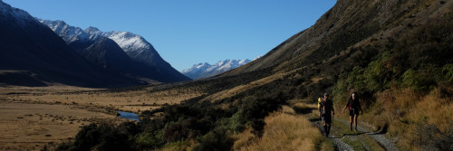
Te Araroa trail section: The landscapes here are superb, amongst the very finest along Te Araroa. The trail is rugged and, though well-marked, is unformed in places. The summits are consistently above 1,500m, often with rocky approaches.
Description
The track has many steep, exposed sections and stream crossings. It's only suitable for fit, experienced and well-equipped trampers.
Anyone attempting the Pelorus River Track and Richmond Alpine Track together as a single section should prepare for at least a 9-day tramp, the first 3 days would be on the Pelorus River Track.
Note: the Department Of Conservation brochure available through the link on this page relates only to the northern portion of this Te Araroa section.
Hacket Junction to Hacket Hut – 1.3km, 15min (and a further 5.7km if starting from the Hacket Picnic Area carpark).
For trampers continuing on from the Pelorus River Track, Hacket Hut is a 15min walk from the signposted junction at Hacket Creek.
For those starting starting this section from the Hacket Picnic Area, about 12km from Hope up Aniseed Valley Road, it is about 5.7 km to Hacket Junction. From the picnic area carpark cross the Roding River footbridge and continue on the formed track towards Browning Hut. There is a Te Araroa direction sign after 5.7km. This is at Hacket Junction. Take the 1.3km track from here towards Hacket Hut as indicated. Alternatively, trampers can remove 20 minutes from this section by taking the first signposted track to Hacket Hut off the track up from the Hacket Picnic Area.
Hacket Hut to Starveall Hut - 6km / 4 hours
The track continues up Hacket Creek with numerous crossings. The track then departs the river and embarks on a 900m climb, initially towards Pyramid Rock, and them on towards Starveall Hut (6 bunks). The hut is located just above the tree line.
Starveall Hut to Slaty Hut - 5km / 2.5 hours
Water can be scarce between Starveall and Mid Wairoa Huts so carry at least enough to last through to the next hut and resupply point.
The track follows poles up towards Mt Starveall and summiting is an attractive possibility on fine days. The main track, however, descends into the forest and follows the ridgeline towards Slaty Peak. A sidle across the peak’s northern face brings you to Slaty Hut (6 bunks).
Slaty Hut to Old Man Hut - 10km / 5 hours
This section is predominantly above the tree line and is marked with poles. Old Man Hut (5 bunks) is located in a clearing and is accessed via a marked side trail.
Old Man Hut to Rintoul Hut - 4.5km / 5 hours
This section is rocky and exposed. It involves some scrambling and is the most difficult portion of the Richmond Alpine Track. Care needs to be taken here and trampers should be prepared to wait out adverse weather.
From the head of the Old Man Hut access track, the main track climbs through the bush and then above the bushline to the summit of Little Rintoul (1643m). It then descends very steeply on a loose surface for 250m following poles to a saddle before climbing steeply again to the summit of Mt Rintoul (1731m), the highest point on the Richmond Alpine Track. This track is very susceptible to erosion which can make for challenging walking so please take great care. Little Rintoul and Mt Rintoul should not be attempted in poor weather.
Beyond Mt Rintoul’s summit, the poled route traverses the ridgeline before dropping steeply down scree slopes to the bushline. From here a marked track leads to Rintoul Hut (6 bunks).
Rintoul Hut to Tarn Hut - 8km / 4.5 hours
The track follows a bush-clad ridge to Purple Top, the only significant open section on the route. Follow poles up and over rocks here to return to the bush. There is a sign-posted junction beyond Bishop’s Cap. The left-hand track leads to Tarn Hut (5 bunks).
Tarn Hut to Mid Wairoa Hut - 6.5km / 4 hours
The track continues along the ridge to a signposted junction before Bushy Top. Take the right-hand track from here down towards the Left Branch Wairoa River and Mid Wairoa Hut. The final descent to the river is steep. The hut is reached across the river via a swing bridge.
Mid Wairoa Hut to Top Wairoa Hut - 7km / 4.5 hours
The track from Mid Wairoa Hut follows the river. It involves a lot of sidling, at times on steep terrain, and eight river crossings. In some areas, erosion on the track presents slippery and/or narrow footholds and extreme care should be taken through here. Some trampers will find this section challenging. It should not be attempted during periods of heavy rain as the river can rise quickly.
Top Wairoa Hut to Hunters Hut - 10.5km / 5 hours
Beyond the hut, Te Araroa enters Red Hills country and a landscape transformed. The track follows markers and climbs away from the hut to a saddle at 1374m.
Beyond the saddle, the track veers northward and sidles, first on a high and exposed ridge and then westward below Mt Ellis towards another ridge. The marker poles on this section are distant but are still visible in clear weather from one to the next. Once over the ridge's shoulder, the track descends and passes through a lightly forested section.
Below the forest, the track veers southwest and down towards Motueka River Left Branch. Cross the river where marked and continue down the true right bank.
Ford the river again where marked and, from the true left side, the track climbs up towards Hunters Hut (8 bunks).
Hunters Hut opened in 1997 and is a memorial to Department of Conservation staff members Russell Griebel and Bob Waldie, both of whom died on duty when Bush Edge Hut was destroyed in a flash flood. Remnants of the old hut are still visible as you cross the river and then make the 15-minute climb up to the new hut site.
Hunters Hut to Porters Creek Hut - 9km / 4 hours
The track undulates south and crosses a number of open boulder fields and streams on its way to Porters Creek Hut (6 bunks).
Porters Creek Hut to Red Hills Hut - 10.5km / 5 hours
The track curves around to the Motueka River Right Branch and, once there, sidles above the true right bank to a crossing near the Maitland Creek confluence. The Motueka river can rise, and fall, very quickly after heavy rain. Take care in crossing and be prepared to sit it out if required. The track then climbs and sidles above Maitland Creek's true right bank towards Red Hills Hut (6 bunks), which opened late in 2009 and replaced an older hut.
Red Hills Hut to Tophouse Road – 12km / 4-5 hours
- Note: There is no water supply on this route between Red Hills Hut and SH63/St Arnaud
After Red Hills Hut, Te Araroa completes the Richmond experience on the Maitland Ridge Track - this was constructed as a MTB track by local volunteers and we are very grateful to share it with them. Take care on this route as it is used by mountain-bikers who may be moving at speed in some areas.
From Red Hills Hut an old 4WD track climbs steadily uphill to a rocky knoll at 1,050m. Go down the ridge to a broad saddle before (at times steep) climbing to a high point of 1,200m, through lovely beech forest. Then a long downhill with some zigzags that keep the gradient smooth with open patches that offer occasional spectacular views. The saddle is at 1,040m then another climb follows to the 1300m high point of the track where you have a great vantage point over the surrounding area. Finally, a steep descent (more zigzags) to the Tophouse Road.
From Tophouse Road it is 750m to SH63 then an 8km (2hr) walk on the road shoulder to St Arnaud.
There are toilets and rubbish bins available just as you arrive in St Arnaud, across the road from the school, next to the Community Hall.
Ecology
The track is within the Mt Richmond Forest Park. Below the tree line, the forest contains a mixed variety of beech and podocarp forest.
Towards its end, the track traverses the flanks of the Red Hills. These hills, formed from mineral-rich ultramafic rock, are barren and the vegetation that can survive upon them is sparse and stunted.
Conditions
Potential Hazards
- Summits are consistently above 1,500m
- The track can be difficult and unformed at times – please take caution
- Hunting is encouraged in Mt Richmond Forest Park. All hunters must have a Department of Conservation permit. For a permit contact the Nelson Regional Visitor centre or a local Department of Conservation office.
Dogs with a Department of Conservation permit only. Contact the relevant Department of Conservation office to obtain a permit.
Access
Most trampers start from the Hacket road-end, 29km south of Nelson and walk through to Starveall Hut to begin the Alpine Route.
An alternate exit from the Richmond Ranges - from Tarn Hut complete the trip by descending to either Wairoa Road-end, inland from Wakefield, or to the Goulter Road-end, on the north bank of the Wairau River.
The Alpine Route is also accessible on tracks from the Goulter River or Lake Chalice.
Transport
For transport to or from Hacket Picnic Area
- Trips and Transfers Nelson Lakes and Beyond is a local transport company in St Arnaud. I can pick you up from the track end and take you into St Arnaud or to Nelson /Blenheim airports if required. Accommodation in a rural retreat (suitable for single person or a couple) available. Jennifer P: 03 539 4896 or make a transfer request online – E: kiaora@tripsandtransfers.co.nz
- Private Driver Hire P: 0272 565 643 (Paul) - can transport to/from all locations Picton-Anakiwa-Pelorus Bridge-Nelson-St Arnaud, priced on enquiry. We can collect from the Hacket carpark and drive to Nelson or to re-supply and go back in again. You will need to contact us from Starveall hut as there is no phone coverage at Hacket hut or the carpark.
- Nelson Lakes Shuttles - P: 03 547 6896 or 0275 476896 – Scheduled transfers between St Arnaud and Nelson, including destinations in Nelson Lakes National Park and stretching to Boyle Village. Prices on enquiry - E: info@nelsonlakesshuttles.co.nz.
Accomodation
Alpine Lodge St. Arnaud - Lake Rotoiti, Nelson Lakes National Park (St Arnaud Village) - E: info@alpinelodge.co.nz - P: 03 521 1869 - W: Dorm and double private rooms plus hotel rooms available. There is internet, laundry facilities, spa pool for hire, an excellent restaurant/bar/café. The Alpine Lodge can store food parcels - $15 per parcel, $20 for a large box - staying/not staying at the lodge. Alpine Lodge, 75 Main Rd, St Arnaud, RD2 Nelson 7072. (Clearly mark the parcel with "<your name>, Te Araroa Walker, eta").
Tophouse Historic Inn and Mountain View Cottages. Hotel, Motel, B&B. 68 Tophouse Road R.D.2 Saint Arnaud - P: 035211269 or 0273444027, Email: info@tophouse.kiwi. 4 double rooms in the historic Tophouse Inn B&B. and 4 Cottages self-contained with 2 double bedrooms. Meals on request and are situated 2kms from the Red Hills Beeby's Knob exit on Tophouse road. 7kms from St Arnaud and serviced by courier post for your food boxes.
Intro
Te Araroa trail section: This long tramp connects the Travers-Sabine Circuit with the St James Walkway. It's an extraordinary summer tramping experience at the Southern Alps' northern end. St Arnaud is a pleasant tourist village on the shore of Lake Rotoiti. Nelson Lakes National Park is serviced by a network of spacious, popular huts.
Description
St Arnaud to Lakehead Hut - 9.5km / 2-3 hours
The track starts opposite St Arnaud's alpine store. This is on the Black Valley Walk, which heads through beech forest to DOC's Kerr Bay Campground on the shore of Lake Rotoiti.
Te Araroa then joins with the Travers/Sabine Circuit at the eastern end of Kerr Bay. From here the track follows the shoreline through the Rotoiti Nature Recovery Project area to Lakehead Hut. This is about 15min beyond the jetty near the lakehead.
The recovery project started in 1997 and is one of 6 maintained by DOC. Its goal is to restore native biodiversity to the beech forest. A trapping and poisoning programme aims to rid a 5000ha block of introduced pests including cats, possums, stoats, wasps, rats and mice. Kaka and reintroduced great spotted kiwi are two native species that benefit from the project.
Lakehead Hut is NOT covered by the Backcountry Hut Pass from 1 Oct to 30 April each year. Buy a Hut ticket from DoC BEFORE your walk. The adult price for summer is now $25. The Backcountry Hut Pass can still be used for camping at any time.
Lakehead Hut to John Tait Hut - 12km / 5 hours
The well-graded track continues from Lakehead Hut up the river flats through open and forested sections to John Tait Hut. Mt Travers comes into view around Hopeless Creek.
John Tait (1901-1982), a former president of the Nelson Tramping Club, led a volunteer effort to raise funds and to construct the original hut in 1951. This was 5 years before Nelson Lakes National Park became New Zealand’s 8th national park. The original hut survived 27 years. A new hut sits in a clearing with views of Mt Travers and Mt Cupola.
John Tait Hut is NOT covered by the Backcountry Hut Pass from 1 Oct to 30 April each year. Buy a Hut ticket from DoC BEFORE your walk. The adult price for summer is now $25. The Backcountry Hut Pass can still be used for camping at any time.
John Tait Hut to Upper Travers Hut - 6km / 3 hours
Beyond John Tait Hut the track continues up the Travers Valley and has some steeper sections. The track passes marked turn-offs to Cupola Hut and Travers Falls, which is a short and worthwhile side trip.
Upper Travers Hut sits on the edge of a large flat immediately below Mt Travers.
Upper Travers Hut is NOT covered by the Backcountry Hut Pass from 1 Oct to 30 April each year. Buy a Hut ticket from DoC BEFORE your walk. The adult price for summer is now $25. The Backcountry Hut Pass can still be used for camping at any time.
Upper Travers Hut to West Sabine Hut - 8km / 6-8 hours
The track continues as a defined ground trail that follows snow poles up to Travers Saddle (1787m). This is a steady 450m climb.
From the Saddle, the snow poles continue down the western face to the tree line. The track then takes walkers down to the East Branch Sabine River in the valley floor below. This is a long and in places steep descent and crosses a large avalanche risk zone. Take the alternative marked track during times of avalanche risk.
From the East Branch Sabine River, the track climbs, sidles and then descends to the West Branch Sabine River. West Sabine Hut is a short distance upstream.
West Sabine Hut is NOT covered by the Backcountry Hut Pass from 1 Oct to 30 April each year. Buy a Hut ticket from DoC BEFORE your walk. The adult price for summer is now $25. The Backcountry Hut Pass can still be used for camping at any time.
Change to Travers Saddle Track
Note for NZTopo50 map users. The Te Araroa map for this section is based on LINZ Topo50 map (BS24 Mount Robert 2018). The black dashed line does not correctly show a later modification to the route. The yellow Te Araroa route is correctly marked on Map 99. At km 2002 southbound follow the poled route down the ridge. The older route, still shown on the maps, is visible leading to the right, but was abandoned due to track damage in the steep valley. For northbound travel follow the poled route up the ridge after km 2004.
West Sabine Hut to Blue Lake Hut - 7km / 3 hours
Te Araroa leaves the Travers/Sabine Circuit from West Sabine Hut and continues up towards Blue Lake and Waiau Pass. Trampers wishing to return to St Arnaud can continue on the circuit.
From the hut follow the Blue Lake Track up the West Branch Sabine River to its source. The route is forested and climbs steeply in places, in particular during the short final climb to the hut and lake. The track crosses several short avalanche risk zones.
Blue Lake Hut is a popular side trip to the Travers/Sabine Circuit.
Blue Lake Hut is NOT covered by the Backcountry Hut Pass from 1 Oct to 30 April each year. Buy a Hut ticket from DoC BEFORE your walk. The adult price for summer is now $25. The Backcountry Hut Pass can still be used for camping at any time.
Conservation – Your help is needed please.
Help stop the spread of lindavia (lake snow algae) to Blue Lake
Lindavia is an invasive microscopic algae that causes a sticky mucus known as lake snow. It is already present in Lakes Rotoiti and Rotoroa. Trail walkers are asked to help stop it spreading to the area’s pristine alpine waters.
Important: Do not swim, wash, take water from or put any equipment into Rotomairewhenua / Blue Lake or Rotopōhueroa / Lake Constance. Your damp swimsuit or water filter may contaminate these pristine lakes.
These lakes also hold high cultural significance to Māori, particularly Ngāti Apa ki te Rā Tō iwi. They are tapu (sacred) and access restrictions have been placed to uphold their mauri (life force) and purity.
Show respect by not touching the water. Not touching the water in these lakes will also prevent the introduction of lindavia. You can swim and fill drink bottles in the Sabine River below the outlet of Blue Lake.
Before swimming or taking water from any other alpine lake or tarn, including Lake Angelus, ensure all your gear has been completely dry for 48 hours. Be extra careful if you’ve recently swum or filled a drink bottle from Lakes Rotoiti or Rotoroa.
Thank you for helping take care of these beautiful places!
See more about lindavia www.doc.govt.nz/lindavia
Blue Lake Hut to Upper Waiau Forks - 7km / 6-8 hours
The next section, over Waiau Pass, is the most demanding on this track. It is a fair-weather route, suitable for experienced individuals or parties with experienced leadership. Good fitness and reasonable agility is a prerequisite for all.
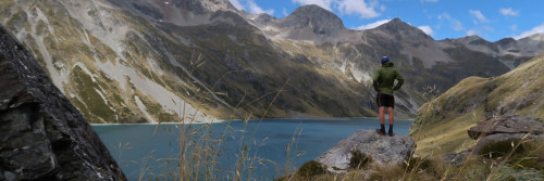
Waiau Pass is a Te Araroa highlight. Allow a full day for the journey.
The track leaves Blue Lake Hut through the forest and climbs onto Lake Constance's moraine dam. The lake itself is attractive and set within a dramatic alpine landscape. From the dam, a rough and rocky track, marked by snow poles, leads up above bluffs on the west side of the lake. Then it descends very steeply in places to the lakehead. The track continues across the open upper valley floor and then climbs a steep scree slope in direct fashion to a high terrace. From here it is a 500m sidle and climb up to Waiau Pass.
The route from the pass continues through the rocky and exposed country. Take care when turning off the main ridge to follow the poled track route as it then drops steeply in places through bluffs to a terrace. Continues west before descending to the West Branch Waiau River in the valley floor. This area is an avalanche hazard zone in Spring and early Summer.
From the valley floor, the track follows the river through thick sub-alpine scrub to the Upper Waiau Forks. There is an attractive informal campsite here within a stand of beech trees.
Upper Waiau Forks to Waiau Hut - 8km / 4hr
The track follows the Waiau River down and stays mostly on the true right. The valley opens up as you near Waiau Hut (6 bunks), new in 2017 thanks to a generous donor.
Caroline Creek Bivouac, which is marked on NZ Topo50 maps at km 2028, was removed by DOC in March 2022.
Waiau Hut to Anne Hut - 26km / 7-8 hours
Travel down the valley is easy, through grassy flats, and on the Waiau River’s true right. Two bush-clad terminal moraines add interest and provide good camping opportunities.
In time the Ada homestead comes into view. The homestead area remains in private hands. Trampers should avoid this area and continue to the Ada River. This is a straightforward crossing in low to normal flows. Beyond the river, trampers link to the St James Walkway and continue down in a south-west direction towards Anne Hut – a new 20 bunk hut.
Anne Hut to Boyle Flat Hut - 15km / 6 hours
The track continues up the Anne River through a series of grassy clearings towards Anne Saddle. Then it descends into the Boyle River Valley.
The small 3 bunk Rokeby Hut is lower down the valley. Built in 1965 it is in original condition. Beyond Rokeby Hut the track continues downstream on the true left to a swing bridge. Boyle Flat Hut is a short distance beyond down the true right side of the river.
Boyle Flat Hut to Boyle Village - 14.5km / 4 hours
Re-cross the swing bridge and continue southwest on the walkway. The track sidles through a gorge and descends to a junction. Cross the river on a swing bridge here and continue on the track within the forest margin. In time the track crosses the river on another swing bridge and continues down towards Boyle Village. The track emerges at a carpark next to the Boyle River Outdoor Education Centre.
Conditions
Track standard: Tramping track
Snow and avalanche risk
At 1870m, Waiau Pass is Te Araroa's second-highest point. It's the most likely part of the route to be blocked by snow and has some avalanche risk on its southern face. Contact the Department of Conservation (DOC) before you start, to enquire about the route's current condition. DOC is at the Nelson Lakes Visitors Centre in St Arnaud (03 521 1806).
Potential hazards
- In winter and spring some sections are snowbound and avalanche prone
- River crossings - Never cross flooded rivers Take care with Wairoa, Motueka, Waiau and Ada Rivers, these rivers are unbridged
- Weather extremes - snow or heavy rain can occur at any time of the year
- Steep drop-offs Avalanche zone - Travers Saddle, track to Blue Lake, Waiau Pass
Nelson Lakes (Visitor Centre) weather - NIWA
Nelson Lakes (Angelus Hut) weather - NIWA
Nelson Lakes (Travers Saddle) weather - NIWA
St James Walkway (Christopher Hut) weather - NIWA
Access
Transport
- East West Shuttles - P: 03 789 6251 - Shuttles run between Westport and Christchurch – via Lewis Pass, Boyle and Hanmer Springs. You must book for the Shuttle to stop at the Boyle. Call to book and confirm pricing. Bookings also available online during the season.
- Hanmer Tours & Shuttles – P: 03 315 7418, E: info@hanmertours.co.nz Will Shuttle from / to the Boyle or from/to Windy Point for a minimum $150 one way for up to 5 people. Call for availability.
- Nelson Lakes Shuttles - P: 03 547 6896 or 0275 476896 – Scheduled transfers between St Arnaud and Nelson, including destinations in Nelson Lakes National Park and stretching to Boyle Village. Prices on enquiry - E: info@nelsonlakesshuttles.co.nz.
- For a Shuttle Service to Hanmer Springs, contact Kirsty Innes on 03 315 7772 or 027 466 7305.
- Private Driver Hire - P: 03 3910500 (Paul) - can transport to/from all locations Picton-Anakiwa-Pelorus Bridge-Nelson-St Arnaud, priced on enquiry.
Accomodation
Hut Pass use
Some Huts on the Waiau Pass Track are no longer covered by the Backcountry Hut Pass from 1 October to 30 April each year.
Hut tickets must be purchased from DoC before your journey. The adult price for summer is now $25 per hut per night. The Backcountry Hut Pass can still be used for camping at any time. Backcountry Hut Pass holders who camp at huts may use the hut facilities
This applies to Lakehead Hut, John Tait Hut, Upper Travers Hut, West Sabine Hut, Sabine Hut, Speargrass Hut, and Blue Lake Hut. These huts cannot be booked, first come, first served.
A few TA walkers have been challenged after assuming the Backcountry Hut Pass was sufficient for these huts. DOC staff will check.
Angelus Hut, a popular diversion off Te Araroa on the Mt Robert Route, requires advance booking and payment year-round. Outside of the peak season, you can use your Backcountry Hut Pass number to apply a discount.
Alpine Lodge St. Arnaud - Lake Rotoiti, Nelson Lakes National Park (St Arnaud Village) - E: info@alpinelodge.co.nz - P: 03 521 1869 - W: Dorm and double private rooms plus hotel rooms available. There is internet, laundry facilities, spa pool for hire, an excellent restaurant/bar/café. The Alpine Lodge can store food parcels - $15 per parcel, $20 for a large box - staying/not staying at the lodge. Alpine Lodge, 75 Main Rd, St Arnaud, RD2 Nelson 7072. (Clearly mark the parcel with "<your name>, Te Araroa Walker, estimated date of arrival").
Accommodation at southern end of route
Boyle River Outdoor Education Centre - Te Araroa Services 2023-2024 Season
The Boyle River Outdoor Education Centre is a not-for-profit organisation, primarily providing programmes for secondary schools. We are on the trail - SOBOs will arrive from the Waiau Pass route, and NOBOs from Harper Pass. As we are able, we are providing some services for Te Araroa walkers. We appreciate your understanding that we may not always be readily available to help you.
Enquiries: Phone 03-315 7082; Email: info@boyle.org.nz
Hours of opening: Monday-Thursday 9am-5pm; Friday, Saturday, Sunday 9am-3pm
This season BROEC are providing:
Parcel storage – bounce boxes
Size 3 box (Regular size) $25; Size 4 box (Large) $35
- Post your box to
Boyle River Outdoor Education Centre, Private Bag 55002, Orchard Road, Christchurch 8154
Do not post to our physical address – your parcel won’t arrive
Use NZ Post – other couriers do not deliver to the Boyle
- Label your parcel clearly with your
- Name
- Contact phone numbers and emails address
- Your expected date of arrival
- Go -on-line and pay for your box at https://www.boyle.org.nz/shop
- Make sure the details you use on-line match those you used on your box label
Accommodation
- You cannot book accommodation ahead of your arrival. If accommodation is available on the day, you will be able to stay
- Accommodation includes hot showers, cooking facilities, laundry and Wi-Fi
- $45 per night per adult. Payment by cash or on-line will be arranged when you book in.
Food and Gas Supplies
We operate a small shop with camping gas (230g and 450g), cold drinks, chocolate and other basic supplies. This season, pizzas are only available if you are staying the night.
Other facilities nearby
- Limited Cell phone reception near the DOC carpark for those on Spark.
- DOC Boyle Campsite – a Standard Campsite adjacent to the DOC carpark with 10 tent sites, a toilet, and untreated tap water. Pay cash on arrival at the self-registration ($10 per adult)
Backcountry hut tickets and annual hut passes are not valid at this campsite. - Hanmer Springs – a township 55km from the Boyle, with a range of accommodation, grocery shops, cafes and restaurants, and hot pools. For a Shuttle service to Hanmer Springs, contact Kirsty Innes on 03 315 7772 or 027 466 7305.
Hanmer Springs
- YHA Hanmer Springs - Kakapo Lodge, 14 Amuri Avenue, Hanmer Springs P: 03 315 7472 E: hanmersprings@yha.co.nz
- Hanmer Backpackers - 41 Conical Hill Rd, Hamner Springs - P: 03 315 7196 - E: info@hanmerbackpackers.co.nz
- Numerous other accommodation providers at most levels.
Reefton
- Reefton Old Bread Shop Backpacker - 157 Buller Rd, Reefton - P: 03 732 8420 - E: breadshopbackpackers@gmail.com
- The Old Nurses Home Accommodation - 104 Shiel St, Reefton - P: 03 732 8881 - E: reeftonretreat@hotmail.com
Food and Supply
Hanmer Springs
- Hanmer Springs Four Square Supermarket - Conical Hill Rd, Hamner Springs - P: 03 315 7190
- Hanmer Springs Foodway - 45 Amuri Ave, Hamner Springs - P: 03 315 777
Reefton
- SuperValue Supermarket - 65 Broadway, Reefton - P: 03 732 8313
- 4 Four Square Supermarket - 47 Broadway, Reefton - P: 03 732 8888